Friday, December 28, 2018

January outlook

Might be hard to believe that 2018 is quickly coming to a close. Here are just a few of the big weather stories that we covered this year:
  • Record late start to tornado season - made it all the way to the end of April without a single tornado reported in Kansas and Oklahoma
From the blog post April 20
  • EF3 tornado that hit in northern Salina county and southern Ottawa county
  • EF3 tornado that hit on June 26th in Eureka
Downtown Eureka
  • Record rainfall in October
  • Earliest measurable snowfall for some areas (mid-October)
We've now had two blizzards in Kansas and winter is just barely getting started. And overall, we've had some fairly mild weather in December, but we think most of January is going to be quite cold! 

January Outlook:
I've mentioned it here several times before, but watching the Arctic Oscillation (AO) unlocks some clues to longer range temperature patterns (not just for Kansas but much of the USA). We see it going well into the negative for most of January, and when that happens, we should get a temperature pattern that looks like the one below. All of the areas shaded in blue are typically colder than normal with a negative AO.
Several forecast models are showing a negative AO as we head through mid/late January. So we expect to have many different cold snaps in the weeks ahead. And some of them will last more than just a couple of days.

We already see temperatures below normal to kick off the new year. Just take a look at the forecast through January 5th. 
January 9-14 should look like this:
Millie and I wish you a Happy New Year. We hope you'll stick with us in the new year as we see what Mother Nature has next for Kansas.

Thursday, December 27, 2018

Winter storm update - Look what's about to happen

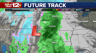
An impressive storm is now working it's way out of Kansas, but not before dumping a major amount of rain on the Plains. I say major because for December, you don't normally get amounts like this in the colder season. However, it fits right in with the wet winter we have been forecasting.

Here are some of the latest winter storm reports:


Rainfall reports from the latest storm:
Medicine Lodge: 2.42"
Hutchinson: 2.26"
Winfield: 1.85"
Wichita: 1.72"
Liberal: 1.67"
Salina: 1.38"
Newton: 1.22"
Hays: 1.20"
Russell: 1.16"
Dodge City: 1.15"
Goodland: 0.06"


This weekend - a weak system setting up Saturday over New Mexico and western Texas could lead to a few flurries over southern Kansas. This shouldn't create any travel headaches as the snow will be rather light. But with the abundance of clouds, temperatures will likely stay cold.

Major Cold Air Coming!
We can see the coldest air of the season sneaking south into New Year's Eve Day.

The big surge of Arctic air will settle over the central Plains on New Years. We should expect single digit lows (and maybe below zero if you have snow on the ground) and highs will in the teens for much of the area. This will be the coldest air of the season.

There is a good chance this bitter snap will be around for a couple of days, but by the first weekend of the new year, it should be easing and temperatures climbing back above normal. 

Thursday, December 20, 2018

Confidence is growing

We are certain that as we look ahead to the next week across Kansas that things are going to be getting interesting for the Plains. Here's what we are confident about:

  • Saturday night flurries in western Kansas won't be much - travel not impacted
  • Christmas Eve/Day look good for travelers in the Plains
  • A storm arriving just after Christmas looks wet - not white
This weekend:

A cold front will push through very early Saturday. Temperatures will begin dropping, but again, it's NOT Arctic air. So most of us will still get highs in the 40s to near 50. You can see a small area of northern Kansas may catch a few flurries later Saturday night, but this is not much of a storm and moisture is VERY limited. 

Santa's Arrival:
Looking good this year. A front may pass through on Christmas Eve (Monday night), but it does little more than drop temperatures for Christmas. So I would expect mainly 30s and 40s for highs in Kansas. Still looks dry.

Storm after Christmas (Wednesday):
This storm has potential to bring widespread precipitation. In Kansas, this is likely a rain event (no ice or heavy snows).  Two reasons to believe it won't be snow: 1) Arctic cold is still well north of Kansas; 2) Track of the storm is WAY too far north.

We should also be preparing for it to turn quite cold again very soon. I expect heading into the New Years holiday that we will see the mild weather depart and bitter cold settle in. January could be a long, cold month. Stay tuned. Have a very Merry Christmas.

Wednesday, December 19, 2018

Signs of a storm

Less than a week to Christmas and I hope you are not totally stressing out right now. The weather hasn't been very stressful as of late with mild temperatures and mainly dry weather over the area.

We don't expect any radical shifts in the weather for the remainder of the week. Even into the upcoming weekend, it's unlikely to change dramatically. 
The bitter cold temperatures (Arctic air) is lodged up in central Canada and not likely to move south for a little while yet. We look at the "AO", which stands for Arctic Oscillation. When its positive, you are more likely to be mild. When it goes negative, watch out. The area circled indicates where we've been lately. But notice it dipping down around January 1st. It's going to turn cold (and perhaps very cold) right around the first of the year. 

This weekend:

One feature to keep an eye on will be coming over the Rockies Saturday night/early Sunday. There's a chance this system will bring some light snow or flurries to eastern Colorado and parts of western Kansas. It's doubtful that we will get much from this system, given that it's coming right over the Rockies and likely starved of moisture. 

Healthy storm next week:

Just beyond Christmas, we could see a big storm developing in the Plains. Confidence on precipitation TYPE and AMOUNTS is low at this stage, but the computer models have been hinting at something developing. The lack of cold air lately is suggesting this might be more of a rain producing system rather than a ton of snow, but it's really hard to say when you are still a week away. But anyone planning to be on the roads just after Christmas should take note of this potential storm. 

We will provide updates online and of course, right here on the blog. Have a great day.

Monday, December 17, 2018

What to watch for as we head to Christmas

Welcome to Monday everyone. A week before Christmas and everyone seems to be moving fast these days trying to squeeze everything in. 

We are currently experiencing one of the driest stretches of weather we've had all fall season. One storm right after another has wiped out drought conditions across the Plains and the ground is still fairly wet in many areas. Winter begins Friday, so let's see what's coming this way.

Midweek changes:

A cold front will push into Kansas on Wednesday. It brings a bunch of clouds with it and maybe some sprinkles or drizzle, but measurable moisture is VERY unlikely. The chances for rain showers will be a bit higher EAST of Kansas.

Very windy midweek too:


Be prepared if you are traveling Wednesday and Thursday the wind will be very gusty. Some gusts will go over 40 mph from the north. Although temperatures will be much cooler Thursday, we still don't have Arctic air plunging this way. So... the temperature change late week won't be that unusual for mid-December. 

Looking ahead to Christmas:

We made the prediction a week ago that Kansas would not have a white Christmas this year. I now it's a bummer for some of you. Chances in any given year are only about 10-15% and it's just not in the setup for this year. Temperatures will be cooling back to near normal on Christmas. Most of us should be expecting 30s and 40s for highs. Good travel weather is expected for most leading up to the holiday.

Thursday, December 13, 2018

Meteor shower peaks tonight - viewing forecast

Out of all the annual meteor showers we get, the Geminids ranks up there close to the top. It's worth checking out and since our Future Track has most of Kansas in the clear heading into Thursday night. A low deck of clouds may still be hanging over south central areas and the Flint Hills (this is the backside of the major wind generator that is moving through the Plains)

The meteor shower should peak around 6 a.m. Friday morning. In order to get the maximum experience, you have to get away from the city lights. In optimal viewing areas, you might see a meteor every couple of minutes. The moon will set just after 11 p.m. Thursday night, so that gives most of the night some very dark sky.


  • Just look straight up
  • Best time is anytime after dark, but will likely peak in the very early AM hours Fri.

Remember, the size of these meteors are roughly the size of sand pebbles, so very small. It's amazing we are able to see them at all, but as they burn up in the atmosphere, they certainly put on quite a show.

Enjoy a great weekend of nice weather. Temperatures will be in the 50s for both Saturday and Sunday and without much wind, we should end up with a great weekend for something outdoors.

Next week (Dec. 17-22):

Looks very warm - so expect some pretty comfortable weather by December standards to continue throughout the week.

Christmas Eve & beyond:
The models are trending toward cold weather, but it won't be here until just before Christmas, and right after the holiday, it looks to stay rather chilly. It also turns stormy once again around Christmas too, but as we mentioned earlier this week on the air, I'm still not seeing a White Christmas for much of Kansas. But we can keep dreaming.

Tuesday, December 11, 2018

Watching the next storm & temperatures leading up to Christmas

Good Tuesday to you and thanks for spending a few minutes reading this blog. We are at the start of what should be an overall milder stretch for Kansas and the central Plains. Now that doesn't mean we aren't going to have some chilly mornings (this is December after all), but afternoon temperatures will likely be above normal for several days coming up.

Here's what we see happening Thursday. The approaching storm comes right over the Rockies, which already suggests to me this won't be a major storm for Kansas. There's a good chance that 90% of our area won't get any precipitation at all. Areas along and southeast of the turnpike could pick up some rain showers Thursday morning or early afternoon, but chances for snow are limited. The only snowflakes we'll see MIGHT come right at the end of the event (and even then it won't be much)

Computer models are giving us light amounts of rain:

Temperatures will be warm enough that we will NOT have icy roads.

Chances of a White Christmas?

I've been asked that numerous times already. Here's what we do know at this point. It will be turning cold again right in time for Christmas. So even though the next 10 days look fairly mild, the pattern will flip again just before the holiday. We expect temperatures to turn cold over much of the central and northern Plains.

Just take a look at the period of Dec. 17-21:

And the period Dec. 21-26 begins to flip around to cold:

Have a great day.

Friday, December 7, 2018

Shifting pattern & a meteor shower coming up

Enjoy your weekend and the first weekend in about 3 weeks that we haven't had a storm barreling through Kansas. You'll remember the blizzard came right after Thanksgiving followed by a storm last weekend that produced some rain, thunder, and then snow in northern Kansas.

The weekend storm stays south of Kansas and the biggest impact might be the flooding rainfall that will show up in Texas and Louisiana.

Next Week - Changes:
Our weather pattern will be shifting to a milder stretch across the Plains. One of the things we look at this time of the year is the AO (Arctic Oscillation) and when it goes positive (+), we typically see a warming trend in temperatures. It doesn't mean that it CAN'T snow, but chances are diminished to some degree. Next week, the AO is positive and that means most of the bitter cold (Arctic air) is going to be locked up over Canada. It doesn't mean we will be running around in shorts and t-shirts, but maybe we won't need as many layers.

The one feature to watch next week is the approach of a storm coming right over the Rockies around Wednesday night/Thursday time frame. Most of the times, storms that approach Kansas straight Rockies are starved for moisture and NOT well put together. But it is one we'll have to keep tabs on because if it slows down and latches on to some moisture, it could dump some snow on our area.

So for now, we'll call it a chance for rain/snow mix during that time, but we won't know very much about the storm until early next week.

Meteor Shower:

The December meteor shower coming up is called the Geminid meteor shower. It's not one of the better ones for us to view, but it is something to mark on the calendar if you enjoy these kinds of things. What will help us out is that the moon will not be shining, so even the more faint meteors will be visible. The Perseid meteor shower is still one of the best ones to view.

However, if we can keep the clouds away, this one might be worth checking out (if you don't mind braving the cold)

Thursday, December 6, 2018

Latest snowfall track

The forecast for snow into the weekend hasn't changed very much in the last 2-3 days. This weekend storm still looks to target Oklahoma and areas near Amarillo. As we've been saying, there could be some slight changes in the overall path, but I don't expect it will change the outcome much.

When does it start?
The storm should be producing widespread rainfall by Friday afternoon and evening (across Texas and southern Oklahoma).

Saturday 1 a.m.
The storm is producing wintry weather for areas SOUTH of Kansas. It will be moving to the northeast.

7-8 a.m. Saturday:
The light snow will be crossing over into southern Kansas. Meanwhile, western Oklahoma and northern Texas will be having very heavy, wet snow. It could accumulate to the tune of 1-2 inches per hour. 

2-3 p.m. Saturday:
The light snow has moved into south central Kansas and will continue for several hours. We still think areas south of Wichita could get a few inches of snow, but IN Wichita, it will likely be under 1" of accumulation.
There is a great deal of Gulf moisture getting pulled north into the storm, and several areas will see in excess of 3-4 inches of rain (or more). It is once again, another widespread storm.


What's next (after the weekend storm):

Temperatures will moderate (warm) a fair amount by the beginning of next week. How does 60 degree weather sound? It might not be that much of a stretch for some of the Plains states. We also should have several dry days coming next week too. 

Tuesday, December 4, 2018

Late week storm update

Thanks for spending a few minutes reading the latest on our next storm that we are concentrating on. It's already in the national headlines today about mudslides in California and heavy rain over the burn scars from last month. It's yet another powerful storm in what continues to be a very active setup across the country.

I understand there are some WILD snowfall forecasts circulating around on social media. The sad part about those misleading forecasts is that it doesn't do anybody any good. So hold off until later this week when we know for sure what's likely to happen. We will have a really good idea by Thursday at the latest.

We are still fairly certain this next big storm will slide mainly south of Kansas. Southwest and south central Kansas should be on the northern fringe of the real active stuff. Oklahoma and Texas should catch the brunt of the storm. Our Future Track is pegging the heaviest snow to fall in western Oklahoma, but again, the track this far out is still a bit uncertain.

Snowfall Checkup:
Most of Kansas is running above normal on snowfall for this point in the season. Winter hasn't officially started, and Concordia is already about 13" above average. Even most of central and southern Kansas has had more snow than the last few years combined. It's been a very busy start to the winter around here.

Next Week (2nd full week of December):
This should be a milder stretch for Kansas. Now that doesn't mean we will escape without needing coats or gloves, but afternoon temperatures should mainly be in the 40s and 50s (rather than the 20s and 30s that we are seeing this week)

Monday, December 3, 2018

Yet another storm to watch

Now into December and the active weather for the Plains shows no signs of easing off the throttle just yet. By the way... welcome to meteorological winter!

The weekend storm decided to spin around and produce some big snows in Nebraska. Just look at the snow analysis this morning across the US. There's basically some amount of snow on the ground between central Kansas and Canada. Last year at this time, hardly anything around the country. So this winter is starting off VERY different than anything we've seen recently.
2018 Snow Cover (Today)


2017 Snow Cover (on December 3)

Late Week Storm Update:
We do have another storm to watch at the end of the week. It's expected to form in southern California and track into the Plains by Friday/Saturday. One computer model (which I think is closer to being correct) keeps the storm across Oklahoma and Texas. (This is the European model)

Still another one has a major dumping of snow for central and southern Kansas arriving into Saturday. (This is the GFS for those who are super weather savvy)

Please be careful about what weather information you share on social media this far out. We don't really know which model will nail the storm. It could be somewhere in between, but we are confident there WILL be a storm at the end of the week.

Have a great day. I'll be updating you on this throughout the week both here and on air. Stay warm!

Blog History