Rain chances continue through Monday!!
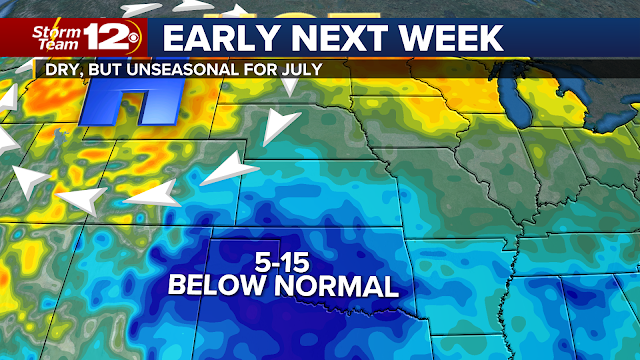
I know we have many dry areas in Kansas waiting on rain. We are dealing with a stalled front that will stick around through the weekend AND we may still have some leftover rain on Monday. Some places could get a bunch while other areas may get enough to settle the dust. That's the challenge in making these forecast, but don't be too discouraged if the first round of rain misses you. Chances increase Saturday evening and again Sunday. The model forecast above takes into account weekend rains and what we might get Monday.
The seemingly endless heat wave that has covered much of the west this summer is about to shift once again as we head into our third full week of the month. The center of the high was located in Southern California for much of the past week, but it will move to Wyoming and the Northern Rockies in the coming days. As we've already seen this summer, that puts the hottest temperatures in places that are otherwise considered an escape from summer scorchers.Just look at some of the temperatures the models are predicting for Monday:
And Tuesday:
This is basically a repeat of what happened back in June when much of the northern Plains had record temperatures.
Kansas will end up underneath of that huge heat dome - so we should have really nice weather for a good chunk of the week. Highs look to remain in the 80s. Just know that the setup for rain is NOT looking good for Kansas during the week. This kind of pattern should keep us rain/storm free.
We could see the upper high settle into the central Plains down the stretch. Models aren't overly clear on how strong it will be, but I'd be preparing for the hottest weather of July arriving next weekend (July 23/24). I don't think it will be days and days of 100s, but this is a setup that will be looked at carefully as we get closer.
More emergency alerting coming soon!!
Those emergency alerts that hit our phones for Amber Alerts, Flash Flooding, civil emergencies, etc. will soon be increasing. Beginning July 28th (assuming you have the emergency alerting turned on), your phone will notify you if a "destructive" storm is approaching. This means if the National Weather Service issues a warning for a storm producing 80 mph winds OR baseball size hail and you're in the path, your phone should sound the alert tone (regardless of what weather app you have) . You do have the option to turn these off, so you'll need to check your phone settings. Changes like these sometimes catch people by surprise, so let us know if you have questions.


No comments:
Post a Comment