Tuesday, July 7, 2015

Rainfall reports; more coming - and heat is looming once again

courtesy Julie Johnson (31st & Meridian)

courtesy Emily Kester (30th & Martinson)
24 Hour Rainfall reports (as of 7 a.m. Tuesday)
Jabara Airport: 4.21"
Topeka: 4.14"
Wichita: 3.52"
Emporia: 2.34"
Winfield: 1.69"
Newton: 1.40"
Medicine Lodge: 0.85"
Concordia: 0.40"
Hutch: 0.25"
Salina: 0.22"
Great Bend: 0.07"

The next round of rainfall will target south central and southeast Kansas into Tuesday night/early Wednesday. Mondays cold front has stalled out and will be coming back north in the next few days. At it moves back toward Kansas, we will get some more rain.


Western Kansas didn't get much rain and there's even been some problem with smoke coming south from the Canadian fires. Showers and storms are expected to develop and move out of eastern Colorado into western Kansas Wednesday evening/night. Although severe storms are not expected, there could be some pockets of heavier rainfall.


Get ready for the pattern shift at the end of the week. The big dome of high pressure will be shutting the Gulf of Mexico moisture down and allowing the heat to expand over the area. It won't take long to turn up the temperatures. On Friday, most of the area will be back into the 90s with 100s possible by Saturday and Sunday. Oh boy! 


Monday, July 6, 2015

Rain chances return & July heat on hold

Hope everyone had a nice and safe 4th of July. Maybe it didn't feel like a holiday weekend since the actual holiday itself fell on a Saturday. The weather wasn't half bad with high temperatures staying out of the 100s (on Saturday) and no major storms. You don't always get that in early July.
Rainfall forecast from Monday-Tuesday 4 p.m.
Forecast highs into Tuesday afternoon
This new week will start off stormy for some with much needed moisture on the way. After all of the wet weather in May, several locations are now only an inch or so above normal on moisture for the year. So it wouldn't hurt to get another round of rain. We have a slow moving cold front that will not only bring a chance for storms, but also drop the temperatures about 20-25 degrees into Tuesday. The slow moving nature of the front will mean a chance for some heavy rainfall over southern Kansas Monday night.

Overall, the pattern this week will favor smaller storm systems to move out of the Rockies and into Kansas. We have another one coming Wednesday night/Thursday, and a second round of moisture should cross the area. Everyone will have a chance for rain, but the forecast models show the heaviest ending up in western Kansas.

as of Sunday afternoon
Although the temperatures are forecast to heat up to near 100 into next weekend (July 10/11), I still do not see a prolonged period of hot weather (triple digit highs) coming up for Kansas. That might just be music to your ears.

Thursday, July 2, 2015

Tornadoes, smoke, & rain chances

courtesy KSHB -Kansas City
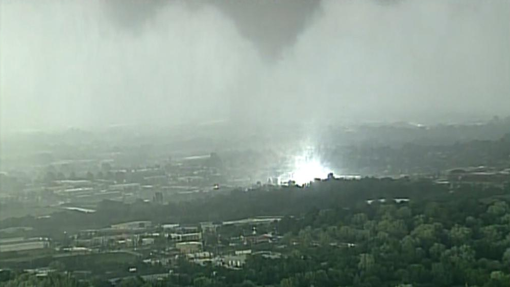
Welcome to Thursday and I know many of you are excited for the holiday weekend. Last night was definitely a little on the stormy side for some in the plains. We watched a couple of tornadoes touchdown in the KC area with some minor damage reported. The picture posted here is a screen grab courtesy of KSHB where their chopper captured some power flashes from a brief tornado that touched down near Lees Summit. July isn't one of the bigger tornado months around this area, but they still happen even though the main severe weather area shifts farther north.

Storms that fired up in south central Kansas moved down into northern Oklahoma, but because the clouds grow 50-60,000 feet into the air, they can be seen from many miles away. Patti Norman sent this picture from Lyons, which would be just over 100 miles from where the storms were when the picture was taken.

Earlier this week on the evening newscast, we were showcasing the smoke that was coming down from Canada from hundreds of wildfires that have been burning for awhile. The smoke was getting high enough to get caught in the jet stream winds, which then carried it southeast through the Dakotas, Iowa, and Missouri. If you noticed the white color in the sky or saw some red color around the moon, most likely it was influenced by the smoke. When it gets high enough into the air to get caught in the jet stream, it's not much of a concern to our breathing down here on the ground.

Heading toward the holiday weekend, we are expecting some showers and storms. The chances for today and tomorrow are going to be very hit and miss. Most areas will probably get missed. We are watching Saturday night and again Sunday night for some storms that may roll out of Nebraska and clip parts of central and eastern Kansas during the weekend. Chances for rain look MUCH better early next week with a front that will be crossing Kansas. Details to come.


Blog History