Effort to erase drought have been ongoing since last summer (which started in western Kansas), and then the rest of us started getting some beneficial moisture in fall and throughout the winter. If you've been following along, we've contributed this mostly to the stronger El Nino that showed up last summer. Now, we are faced with an oncoming La Nina.
First, here's what the water temperatures look like in that critical area that is monitored for El Nino/La Nina:
Water temperatures are 1.7°C above the average, so we are still in the El Nino influence now, but water temperatures have started cooling.
Just see for yourself how things were looking in late September 2023:
And now most recently, this:
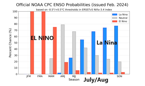
How quickly will El Nino end and La Nina begin? It might be faster than we really want it to be, and you'd have good reason to be concerned for heat and drought in the summer season IF La Nina was going to be back before summer started. I'm not sure that will be the case. See the chart below, and take note of how the red bars drop off and the blue bars begin growing. That is suggesting the strong likelihood of an oncoming La Nina, which could be firmly in place heading into fall.
Quick look into March:
We've sorted missed the mark with our forecast of colder weather for mid-late February. Turns out, whatever cold weather was to be had was so brief that it wasn't even worth covering here. Lol.
But we've been thinking spring season would be a wetter than average one, and that still shows up in the longer range maps. And I'm still not convinced winter is behind us yet. Most Kansans know that March is the wild card month that can have it all. We'll come back and cover March a bit more in depth soon, but here's an early look at what we are seeing:
Temperature -
Precipitation -
Thanks for reading!


No comments:
Post a Comment