Thursday, June 30, 2022

Heading for a July heat wave? And more rain is coming soon

June comes to a close and we have reached the halfway mark of 2022. We had a big heat wave in the middle of the month (lasted nearly 2 weeks) that was bookended by some rain. As you'll be able to see in the map below, June rain was MUCH more spotty than what we had in May. There's been little reduction in drought over the last month. Far southwest Kansas finally had some good rain, as did areas along and just north of I-70 near Hays, Russell, and Salina. South central Kansas had another decent month with some rain. 

As for the 4 major stations we track:

And here's where we are for 2022 on rainfall:

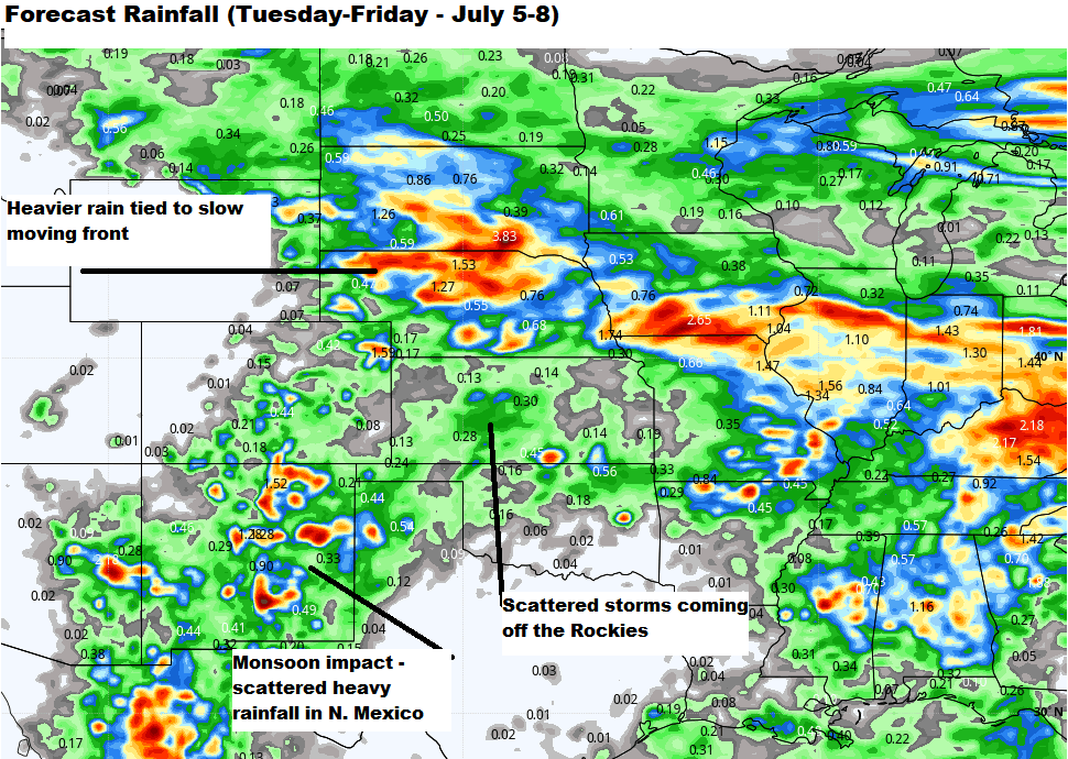
The rain that is expected to hit in the coming days will start north and then spread farther south. Once again, it is a slow moving front that gets about as far south as central Kansas and then comes to a halt. It will retreat back northward by Sunday and take the storm chances out of Kansas by the holiday. Tough to say on how much rain, but the feeling is .50-1" is quite possible, with lighter amounts near the KS/OK state line and maybe not as much across the far west. However, much of the state should get a chance at some rain Friday night-early Saturday. 

No major heat wave next week:

The upper level "high" is likely to shift back to the west of the Rockies. As it does, we will have some energy coming off the mountains and down into the Plains. This should bring another round of storms in the forecast midweek. I expect we will have another cool down coming too, but it definitely doesn't look like the 70s that some of us had late in June. That is hard to come by as we get into the hottest part of the year (climatologically speaking).

Have a great day and thanks for spending a few minutes here.

Friday, June 24, 2022

Busy storm day Thursday - more active days on the horizon

Thursday turned out to have almost as many tornadoes as any other day so far in 2022. One storm in particular, was in the right environment for it to rotate and produce tornadoes. In the image below, you'll see what the temperatures looked like at 3pm Thursday. You'll first notice the distinct temperature contrast from one side of a warm front to the next. Then take a look at the wind arrows. See how the arrows are pointing from southeast to northwest? That tells us the wind is from the southeast. And then look out into central and western Kansas - you'll see a different wind direction there. That shift in wind was key in getting the storm to rotate and produce occasional tornadoes. There's always some degree of concern when you have a warm front involved with severe weather - the shifting wind across the front makes it easier to get a tornado environment and we are lucky most of them were very brief. 


Here are some photos of the various funnels and tornadoes:

Allison Moore - Ellsworth/Lincoln county line

Monica Prewit - 2 miles east of Wilson

Safe to say we won't see this kind of setup again for a while. There's nothing in our near future that would produce scenes like we saw Thursday.

Saturday night/Sunday rainfall - This will mostly be for the southern half of Kansas. I don't think we are looking at a gully washer, but southwest Kansas might get the heaviest rain. Models continue to show in excess of 1" of rain, while farther east, it will likely be under 1".


Next week:
Mainly cool to start the week, but it will heat up gradually as the week continues.


More active weather for the 4th of July weekend:
We are seeing a potential pattern change again around the holiday weekend that may result in more rain chances for the Plains. It's early to pin down the setup, but a series of disturbances coming off the Rockies may set off some storms throughout the area. It may be two or three rounds of rain developing on the High Plains of Colorado and western Kansas and moving southeast. We will have to wait until we get a little closer. I DON'T think we will be as cool next weekend (for the holiday weekend) as what we are forecasting for this current weekend (June 25/26).


Five planets lining up for a show early Saturday and Sunday:

Not a popular thing to do on a weekend, but if you are up extra early, look for the 5 different planets lining up across the eastern sky. You'll have to get out at least 30 minutes prior to sun up (which is around 6:09AM) and binoculars can make the view better. Mercury will be quite low in the sky (but visible), and then you'll have Venus to its upper right. Just above the moon is Mars, Jupiter, and Saturn. Enjoy.

Tuesday, June 21, 2022

Summer arrives with a cool down on the way

Summer is here (as of 4:13 AM Tuesday) and if you feel like it started weeks ago, I'm guessing you aren't the only one with that idea. Most of the state has already recorded it's first 100° day, and for Dodge City, we've almost had half as many 100s as we had in all of last year. And we still have July and August to go:


Did you know that during summer, the Earth is actually farther from the sun than in winter? And sun is directly overhead at the Tropic of Cancer, or roughly 22° north of the equator. 

Our first threat of widely scattered storms comes as a cold front drifts into the area and hangs out through Wednesday. This is a case of hit/miss rain - maybe driving some farmers to move from one field to another because it's so isolated. 

Chances do increase a bit Wednesday, mainly over the southern half of the state. However, we are still talking about scattered stuff and not covering entire areas. Chances of severe weather should remain low given how weak the winds are aloft. Doesn't mean we couldn't have a storm produce some high winds, but I don't think this will be a hail concern. 

The biggest change comes this weekend as STRONG front comes surging across the area. Highs will drop 20-30° and we should manage a couple of days with 70s and 80s around the area. And the humidity will go down as well. 

We will probably get some rain too - looking like northwest Kansas maybe Friday night and the rest of the area Saturday night to early Sunday. 


Initial thoughts on how much rain: expectations are western Kansas may get more than what areas farther east will get, but much of the state will have a chance.


Thoughts on early July as we head toward the holiday & beyond:

I think the upper "high" will gradually shift back to New Mexico and the 4 Corners area. Whether that happens right at the beginning of the month or after the holiday is something we are watching. Some of the models are driving a cold front through just before the 4th of July, so we may end up with some nice weather heading toward the holiday. 

Early 4th temperature outlook:

If this pattern does come to light, our heat should ease with chances for storms coming off the higher terrain of Colorado/Wyoming/Nebraska. This would be a more favorable pattern for storms to occur at night, but details aren't clear this far out. While I don't expect a "cool" July overall, we should be able to avoid a solid month of extreme heat - and some occasional rain (but not likely above average)

Wednesday, June 15, 2022

More heat for the Plains and the monsoon returns

The weather has certainly tamed down this week. Amazing how quickly we shut the rain off and crank up the heat. Perfect timing for combines rolling in the wheat fields and here's to a speedy harvest around the state. Long days and short nights for the farmers. The weather looks like it will cooperate too.

Setup into the weekend and early next week:

A large high pressure will be dominating the upper level pattern. In this kind of setup, it's very difficult for storms to form, much less have anything widespread. This is typical in summer, but sometimes these high pressure systems don't budge and can lead to prolonged heat waves. In the upcoming setup, you'll see big time heat going all the way up to the US/Canadian border. Places that have been getting rain and even some snow are about to see a major flip in the weather. 

I don't foresee a major, prolonged heat wave developing but our weather is not likely to change very much over the next week - 10 days (maybe longer).

Monsoon returns to the Southwest and Colorado:

I don't think this could come at a better time, given that big fires are happening now in New Mexico and Arizona. They have been burning for several weeks, and we are seeing some of that smoke filtering across the Kansas sky. It would appear that between Friday and the beginning of next week, as much as 1-2 inches of rain may fall in some of those areas, hopefully helping fire fighters get the upper hand. 

I mention the smoke because as you'll notice in the image below, upper level winds the next few days will carry it right across the midsection of the country. 

Have a great day. 

Thursday, June 9, 2022

First big summer wave of 2022

The first week of June is in the books and the month has started off with rain - much needed rain. Nearly every part of the state has had at least .50", but there are some spots that have been missed (like just south of Leoti, near Russell Springs, east of Atwood) Some areas have had too much - and others need more. 

Here's the map of measured rainfall:

One rainfall amount that jumped out at us this week was the one coming from Elkhart. Far southwest Kansas has battled drought for many, many months. A big rain like the one that came Tuesday night, doesn't happen that often. 


And as a side note, in the last 10 years, rainfall amounts of greater than 2.50" has only happened two other times (both of them in 2015)

The new drought map just released Thursday morning reveals conditions are better (keep in mind the rainfall cut-off is Tuesday morning - anything after that is not taken into account for this particular week) We've seen a sizeable reduction in the "exceptional" drought conditions, but still a long way to go before we are in good shape. 

Here comes the harvest weather/big heat dome:
First round of heat arrives over the weekend - Monday:

A meandering high over the central and southern Plains will force the rain away for the time being and allow us to start drying things out. 

A second round of hot weather is slated for the Plains next weekend too. Just in time for harvest, the hot weather hits and our rain chances diminish quickly. 

The last 10 days of June (temperature-wise) will most likely remain above normal. 

Have a great day.

Friday, June 3, 2022

Another tornado record - and still on track for heavier rains

What is typically our busiest month for tornadoes comes and goes - and there's another record to report from Storm Prediction Center. The tornado count (which is considered a preliminary number so far) stands at just under 800 across the country (for all of 2022). A rather rapid increase in the tornadoes early in 2022 somewhat leveled off in the last 30 days. 

Here's the impressive stat that sets a record:

I don't have an exact count on Kansas tornadoes for the year, but I believe it is still under 50 (remember the 30-year running average is right around 80-90). The strongest tornado of the year continues to be the Andover tornado from April 29th (rated EF3). 

Drought update:
Big rains in the last 30 days have really helped out, putting some water back in creeks and streams. First, let's look at how much rain over the state from May 2-June 2:

The drought map has changed, but you have to look carefully to see where and what's different. The top map is the new one that just came out, while the map below it reflects the previous week. Notice central Kansas goes from "extreme" drought to "severe", which is an improvement but still a long way to go. Western Kansas (in the last week) has not seen much change. 

The previous weeks drought map:

What are the severe chances in the days ahead?
Right now, I would expect them to all remain low. Even though we have a fairly active stretch of weather in front of us, we probably won't see that many severe storms. Biggest concerns will be flooding rainfall and some storms that may produce gusty winds to around 50 or 60 mph. 

How much rain and when?

The setup will favor overnight and early morning storms. They will have a tendency to start on the High Plains of Colorado, western Kansas, and into Nebraska and then spread southeast through the night. This is pretty common in summertime and will hopefully help ease the drought a bit more. Figuring out which part of the state will have highest chance may not be clear until 24 hours before, but we feel like this stuff will be rather widespread, and even if one round misses you, there's more to come. 

If the models are correct, much of the state will have decent rainfall (greater than 1") with many other areas getting closer to 2-4"+. It still looks like the biggest rains will likely happen in central and south central Kansas - and some of those areas don't need any right now. But it looks like north central will get more good moisture and even the southwest, although maybe not enough to end drought, it will help. 

Thanks for spending a few minutes here.

Wednesday, June 1, 2022

May rainfall records - very active start to June

I should point out here at the start that drought does continue in Kansas, but receives a major setback after the very generous rainfall the month of May had to offer up. At the beginning of the month, I wasn't convinced the rainfall would arrive in the amounts that it did, but we are in better shape than a month ago.

I want to focus on the record rainfall that some had over the last 30-40 days, but we haven't forgotten about the areas farther west that are still in pretty rough shape with the lack of moisture.

Here are the final May numbers for the major reporting stations that we track:


Almost 13" of rain for Wichita and look at Salina - doing much better than a month ago. Both locations have reached the top 5 wettest Mays on record.

Wichita missed 1st place by less than .25" of rain. Most of that came in the last week of the month, while for Salina, much of that came in the last full week (prior to Memorial Day)

So where do we go from here:

The forecast is tricky to say the least because we have several pieces of energy coming off the Rockies and down into the Plains. Every time we see something coming out of the west, it may setoff a new round of rain. It's almost like standing next to a flooded creek or stream, and every piece of debris floating by in the water, sets off a new round of rain. That's what we are up against. Forecasting them is tough and specific details of where the rain will be may not be known until we are 24-36 hours out from the event.

What we take away from this is that over the next 8-10 days, there will be more rain. Good news for those in western and northern Kansas - maybe not the best news for those dealing with flooding. We need to fill farm ponds and lakes - so runoff can be quite beneficial. However, in south central and eastern Kansas, we really could use some drier weather for now. We don't want the rains to shut off completely because we could fry in the summer heat.

Month of June (temperatures):

Right now, it looks like it WON'T be a scorching month ahead for Kansas. The additional rainfall in central and eastern Kansas should moderate temperatures quite well. However, farther west, I would look for near normal heat throughout the month - many more days with highs in the 90s than what we would see farther east.

Rainfall:

This may be reason to smile - especially across the west. While the drought isn't going to be over in 30 days, there may be some help coming. The active pattern to start the month could help ease the stress in the west, but we have a long way to go. Long range models offer hope of above average moisture in much of the state. When we think about average rainfall, for most of Kansas that would be 3-5 inches in many areas - June being one of the wetter months of the year.

Have a great day.

Blog History