Thursday, May 30, 2019

June outlook - will it be as wet?

What has felt like an endless stretch of bad weather is... for now... over! There's so much to clean up in the wake of flooding, hail, and then the tornadoes that have hit different parts of the state.

In case you missed it, the EF4 tornado that hit Linwood Tuesday evening was the strongest tornado since May 25, 2016. That particular tornado (shown below) went north of Abilene and closed in on Chapman. It did some significant damage to a few homes and had estimated winds of 180 mph. (Photo courtesy Kris Sanders) - this picture from 2016

May Rainfall:

It was one of the wettest months of May ever recorded for much of the state. Some areas have had more than half of their annual rainfall in just this month alone. The map above shows some areas with 15-20" - those are the areas in white. You can click on the image to enlarge it.

What will June be like?
First off, June will not have near as much rain as May, BUT... it will still be a wetter than normal month. I would expect that much of the state will end up with about half of the rainfall that we saw in May. And the temperatures won't be anything out of the ordinary. In fact, we might have several comfortable stretches throughout the month.

Early June: Looks very warm... almost hot for some. Temperatures will be near to above normal with some 90s in the forecast during the first week. Thunderstorms are STILL in the forecast, but these will be on a scattered basis for much of the Plains. Some of the storms will have heavy rainfall.

Mid June: We will likely start cooling off during the middle of the month. And rain chances will definitely continue on a scattered basis. But it will be hard, if not impossible, two weeks out to forecast exactly WHERE the storms will be. We do know that the wet pattern will roll on through the middle of the month.

Forecast into the second half of June:


Late June:
Cooler than normal weather should continue across the Plains and in the deep south. This will likely mean mostly highs in the 80s for the area. Much of the region continues to be wetter than normal, which will keep the afternoon temperatures down.

No scorching heat waves in the Plains this summer. The setup just isn't there for that this year.

Tuesday, May 28, 2019

Another active day but changes are showing up

The weather pattern is finally showing signs of change this week and a break from the endless heavy rain is here. All of the active weather created by a stubborn low pressure that was parked in the southwest for the last few weeks. That low pressure is FINALLY coming through the area today and will shove the widespread storms on to the east. HOWEVER, as the low pressure moves through, it does set us up for more dangerous weather Tuesday evening.

Highest tornado threat today: Northeast Kansas
A warm front in that area will lead to strongly rotating storms that could very easily produce some tornadoes. That threat covers Kansas City and areas into Nebraska and Iowa. There will be scattered storms along and east of I-135 after 3/4 pm with most storms producing heavy rains and some hail. I don't expect that many tornadoes south of I-70.


Calmer weather Wednesday/Thursday:
We will finally see the active weather shoved east. The low pressure I mentioned above is rolling through the plains today. As it does, severe weather and heavy rains will shift east of our area for Wednesday/Thursday. MAJOR rains are in the forecast for eastern Oklahoma and parts of southwest Missouri. Where the levees are close to failing, another 2-5 inches of rain could fall Wednesday night, so it could be an extremely serious situation with additional storms headed to the area.


How wet has the month of May been?
It's been crazy to say the least. Some areas have had 1/2 of their yearly rainfall in just the past 30 days. That's why we are making history with many areas having one of their wettest months of May on record. The wettest month ever recorded in Wichita had just over 14" of rain, and we are closing in on that record fast.

Coming up later this week we will look into the month of June and see if there are chances we could begin drying out.

Friday, May 24, 2019

Weekend storm chances AND an end in sight

I hope everyone has a great Memorial Day weekend. We almost always have at least ONE round of storms over the extended holiday weekend. However this year, we get two. Storms will be around Saturday and Sunday, but we continue to forecast DRY weather on Monday. It will be very nice to have the faucet turned off for awhile.

Today (Friday): Storms will redevelop right over south central and eastern Kansas. If you are traveling the turnpike today or this evening, be prepared for some hail and heavy downpours. Our Future Track model is giving the highest storm chances to the 3-11 pm time frame. Severe chances will rapidly decrease after 8 or 9 p.m.


Saturday: 


Storms will fire up early evening across southwest Kansas and then begin moving east. I think it's safe to plan something outside for the afternoon and maybe early evening, but then we will have to be on guard for more storms/heavy rain. Given the setup, I think it's mainly going to be some strong winds/some hail kind of setup (Strongest storms should remain south of I-70). And of course because everyone is so water logged, flooding rains has to be right up close to the top of threats as well.

Sunday: 


A few early morning showers will be drying up in eastern Kansas, but then another round of storms will come at us from the west. It should start after 4 pm in western Kansas and then move east/northeast. Once again, it looks like a large hail/wind threat heading into the evening.

Next week - drying out!!


That's right - Memorial Day looks dry and windy for much of the area. And although Tuesday will have a chance for some storms, almost all of it should be tracking east of our area. The Flint Hills and areas east will have the highest storm chances. But we finally get a shift in the weather pattern that will allow for more dry days than rainy ones. There could be another low pressure system tracking this way at the end of the week, but if it does happen, it should be a fast moving one and not something that hangs around for days and days. Can you imagine how it will feel to have 3 or 4 sunny days in a row?

Thursday, May 23, 2019

Severe threat today AND more flooding

Different day, but the headline remains the same. More severe weather chances and more flooding likely across Kansas. We are basically stuck with this weather pattern through Sunday, then changes should begin to take place.

Today (Thursday):
Scattered storms are already underway across western Kansas and more will develop this afternoon farther east into south central Kansas. A warm front will be coming out of Oklahoma into the afternoon, which will continue to set the stage for strong to severe storms over a big part of southern Kansas. Storms will move northeast with a hail/wind threat, but a tornado or two will be possible in an area east of Dodge City over to Wichita and south. I don't expect we will have a bunch of tornadoes today, but the threat isn't completely taken off the table. 


Of course the other concern is the already ongoing widespread flooding. Where is all of this additional water going to go? That's what bothers me with another 2 to 5 inches of rain coming to this area. 

Friday:
Storms will begin to calm down a bit with spotty rain and some thunder Friday morning AND again a few later Friday afternoon. I don't expect a great deal of severe weather Friday, but a few hail storms & some occasional wind will be possible.

Over the holiday weekend - storm chances will continue. However, most will happen late in the evening and into the overnight.

There is an end to this stormy weather: We are now expecting Memorial Day to be dry. And a cold front will sweep through on Tuesday to start sweeping much of this active weather out of the Plains. It will be nice to have more than just one day of sunshine. 

Tuesday, May 21, 2019

How much longer on this stormy setup?

Thanks for sharing a few minutes reading the blog. I know that most of your reading this are ready for sunshine and dry weather to be back. You hate to say bad things about all of the rain because there are times where we are desperate, but all of it at one time is damaging.

24 hour rainfall reports through 7 a.m. Tuesday:

Today - Tuesday:
Storms will be scattered over the state into the afternoon and early evening. It's not a great chance for severe weather, but given the fact we are right UNDER a low pressure system, the atmosphere is churning pretty good. That could lead to a few hail storms and a brief tornado spinning up around parts of the state. If you get a chance to look at the radar during the afternoon, watch for the counter-clockwise spin going on across central and western Kansas. This will move out of here later tonight.


Thursday storms:
Humidity will be racing back over the area into Thursday, which will set us up for more active weather and some rain. Storm chances should begin in the morning and continue into the afternoon. A few of the storms could be severe, so we aren't out of the threat areas yet. And once again, we are on the lookout for more rain in very soggy areas. Highest severe chances will likely focus over central and parts of western Kansas.

Why so much rain?
Bottom line is we are dealing with slow moving fronts in the area (sometimes not moving at all) AND... you have this HUGE low pressure spinning back in the desert southwest. So every time a piece of that low breaks off and moves to the Plains, we get storms. We have so much available humidity and water nearby that it's not hard to squeeze out more rain for the area. And as long as this low hangs back in the southwest, you will continue to see several rain chances ahead.

I do see a period coming in early June where we should begin to shake some of the rain. Now June itself will likely still have some decent rains, but it's probably NOT going to be as wet as this month of May has been. It's just too much right now.

Friday, May 17, 2019

Storms on the way - Flooding concerns

Hopefully you are ready for more active weather because we are about to enter a LONG stretch of it as we move through the weekend and much of next week. This is definitely fitting for this time of the year as the jet stream is strong, temperatures are warmer, and the Gulf of Mexico moisture seems to have an endless supply for the Plains.

Friday:
I don't think we will see very many storms, but the few that do pop up have a good chance of being severe for a few hours. One of the things that will limit the storms will be some warmer air roughly 9-10,000 feet. Storms, if they can get going, will move quickly to the northeast (maybe 45-50 mph or more). Large hail and wind will be the biggest threats.

Saturday:

Still some unknowns here but I definitely think there will be some strong/severe storms developing after 3 or 4 p.m. These will move east/northeast and produce hail, wind, AND torrential rains. So please be mindful of flooding. We've had a chance to dry things out the past week, but it won't take very much rain to soak things up again. 

Early Next Week:
Here is a comparison on potential rainfall between the two models we look at closely:


There are two things that are concerning here: the steady supply of Gulf moisture AND a slow moving front. This is a bad combination for Kansas because it will lead to heavy rains. I am concerned with how much the computer models are showing for this area. We spend a great deal of time talking about the hail, wind, and chances for tornadoes, BUT flooding will likely impact more people than the hail and wind. So we definitely can't downplay this risk.

Wednesday, May 15, 2019

Severe weather UPDATE

Thanks for stopping by and reading the latest on severe weather chances for late in the week. This will be a little short today as I have several things happening and not as much time to write as I normally would like.

Friday Chances:
Still looks like a late evening severe chances exists for western Kansas. These storms, if they do develop, will be pretty isolated. So it should be a one here, one there kind of setup, BUT... if some storms can get going, they could be pretty strong.

Saturday:
We will definitely have storms on Saturday, but what complicates the entire setup revolves around morning rain/thunder. So we may not know very much until about 24 hours ahead of time where the strongest storms may develop. If you look at our Future Track at 4 p.m., there is a good chance for some storms over central and eastern Kansas. HOWEVER... we just don't know how strong they will be yet because so many other factors come into play during this time.

Early next week:
I am still concerned that we will have severe weather to begin next week. Monday, and maybe Tuesday too, will have strong storms in our area. There's so much wind (in the upper atmosphere) coming from the southwest that will help to energize storms throughout the Plains. So we will have several busy days ahead for Kansas and surrounding areas.

AND... WE CAN'T OVERLOOK FLOODING!!

Forecast models give generous amounts of rain to the area between Friday and the beginning of next week. Many areas could be getting 2-3 (maybe more) inches of rain. This will lead to problems.

Tuesday, May 14, 2019

Severe storms on the horizon again

Hopefully your week is off to a good start. Nice to see some sunshine and drier weather for a change, but severe storms are on the horizon again and we could be going through a rough stretch soon.

Our weather should remain rather quiet through Thursday and even most of Friday isn't looking too bad. But the combination of higher humidity and an approaching storm by Friday night will bring stronger chances of rain and thunder back into the Plains.

Just look at the two maps showing dew points for Kansas. Remember, dew points give us a measure of how much moisture is in the air. Yesterday (Monday) - the map shown above, the air was fairly dry and it was comfortable even as temperatures approached 80°. However, as we get into the middle of the week, the humidity will surge as Gulf of Mexico moisture continues to move north. You will likely feel it by Wednesday or Thursday.

In addition to watching the humidity go up, we will also be seeing stronger winds at 30,000-40,000 feet coming into the Plains. That will increase the chances of larger hail and high winds, and also put us in a spot to see increasing tornado chances too. And this will be a setup that presents itself not only Friday, but Saturday too. So it will be a two day severe weather setup to ease us back into the active pattern.

Then next week... more chances of rough weather. We will have ANOTHER coming from the west. If you look at the map below, you'll see the storm over the Pacific, and that will certainly roll our way at the beginning of the week. So we will surely be talking about more stormy days leading up to Memorial Day.

Thursday, May 9, 2019

Tornado confusion - real or fake?

Many of you might have our Storm Team 12 app on your phone and rely on it frequently to stay up-to-date on where the heavy rains and storms are, and where they are going. There are many wonderful tools contained in the app, not the least of which are the watches and warnings that are issued by the National Weather Service. You also get a future radar, just like the one we show every day on TV.
Well something happened Tuesday night that created some panic and confusion (mainly for those in Cowley county). Take a look at the image above. This is a screen shot from a storm that intensified near Winfield around 9 p.m. and if you look carefully, there's a tornado marker near the storm. It's the red circle with a little tornado in the middle and a storm track that branches out to cover the city of Winfield. (You can click on the image to enlarge it) This had some users thinking either a tornado warning was in effect or that a tornado had been spotted southwest of the city.

This feature on the app (called Storm Tracks) is something that can be turned on and off. In very stormy periods, like we've had this week, if you have it turned on, there might be so many little icons that they cover the entire radar display. Storm Tracks within the app, is a piece of software that uses mathematical equations to help pin down the strongest storms. If you touch the icon, it will give you more detailed information about the storm, such as which way it's moving AND how fast. In the case Tuesday night, the software was calculating some rotation on that particular storm, which placed the tornado icon southwest of Winfield. No tornado was spotted and there was not a tornado warning.

As we've said before on TV, radar just gives one perspective of the storm. While there might have been some rotation in that particular spot, it was never strong enough to warrant a tornado warning. The storm did produce some large hail and we had some wind measured at 50 mph.

Personally, I don't use Storm Tracks because they usually clutter the screen and I would rather just see the radar. But if you are going to continue using the feature, please know it's a computer software calculation and regardless of which icon is where, it's NOT a confirmation of what is actually happening. I wish I had a way to make them better or a way to show only what was ACTUALLY reported, but we don't have any control over when and where they pop up.

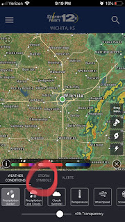
You CAN turn off the Storm Tracks feature, and I'm posting images below to show you how this is done. You WILL still get watches and warnings that you've come to expect, but when you look at the radar, you won't see all those markers that might trick you into thinking you are in a tornado warning. And it's always a good idea to seek out some additional information if you just aren't sure. The app is a great tool, but it does have limitations.

Here's how you turn it on/off. Look for the 3 dots in the lower right corner of the screen:
Then, look for the boxes down toward the bottom and you might need to scroll to the right to find "Storm Tracks". Just by touching on the box will turn the feature on or off.


Blog History