Monday, June 30, 2014

Stormy end to June - nice start to July

Here we are at the start of another week and it's a short week for many with the 4th of July coming up Friday. We are going to get the severe weather out of the way today and tonight, and then watch things settle down the rest of the week.

Let's look at the setup for today. A cold front will be running into some very thick humidity and it looks like after 6 or 7 p.m. tonight, storms will start to develop right along the front. Because of the high humidity and very warm temperatures today, the main threat with severe storms will be some very large hail. The high humidity will also lead to more heavy rainfall. There is a moderate risk of severe weather over northern Missouri, where some tornadoes are even possible late in the afternoon. But, this should be the last of the severe weather that we will have for the week.

Pattern for Wednesday evening showing the hottest weather will be off to the south and west
The pattern is about to shift with some drier and milder air filtering south by midweek. I think our humidity will come down some and highs in the 80s will make for a really nice start to July. Of course, when you consider how hot some of our recent summers have been, we are not going to see anything like that heading into July. Some of you have even asked when will those dreaded 100s show up again. I don't see anything like that coming our way for awhile. Sure, there could be days where the heat index may get that high, but with the recent rains and green vegetation once again, we should have a much easier time staying out of 100 degree territory for several days to come. That may be the best news of all heading into this holiday week, right. Have a good Monday.

Friday, June 27, 2014

Weekend storms

Always feels good to get to the end of the week and in summertime, I know most of you have a lot planned for the weekend. My family is chomping at the bit to get back into the harvest field (as many farmers are) but storm chances over the weekend will likely mess things up a bit. It's frustrating. We don't want to complain about the rain, but the timing is likely to interfere with some of your outdoor plans for sure.
storms headed east this morning
So here is what we are looking at. As I write this entry, there are a few storms across northern Kansas that are headed east and won't likely be a huge factor in today's forecast.
The beginning of more storms heading into Friday night

Storms are expected to develop once again in western Kansas and eastern Colorado and move east heading into Friday night. There will be a chance during the evening hours of some severe storms, but as it moves east, heavy rainfall and gusty winds will be the main threat.

Saturday brings another chance for storms, but the focus will be over the eastern half of the state. And there could be both morning and afternoon storms. So timing on Saturday is a bit in question, but I expect that south and east of the front drawn on the map, that's where the best chances for storms will be heading into the afternoon.
Highest chances for storms Saturday will be over central and eastern Kansas

Sunday will be hot and dry for much of the state. Highs will be going back into the 90s and that's the kind of weather I know farmers would like to have. Of course, not for the rest of the summer, but for a little while, it would be okay. Hope everyone has a safe weekend.
Be prepared for some severe storms Saturday afternoon and evening


Thursday, June 26, 2014

Improving drought & weekend storms

Hope everyone is having a pretty good week so far. I grew up in a farming/ranching family, so I know first hand that the continual rain at harvest time is driving everyone batty. You know the crop is in the field and you can't get to it because the ground is too wet and the grain needs to dry out. And each time it rains, the quality goes down. But then again, we need the rain to keep the grass growing and the corn crops around the state are just loving the moisture. 

As I mentioned in yesterdays blog, some areas of the state have had roughly 40% of their annual rainfall in just the last month. The pattern has definitely changed and the benefit is decreasing drought conditions. Some areas of the state have been dealing with drought for 3 or 4 years, and maybe even longer. And while we have definitely had nice rains and are about to see our yearly deficits go away, the drought isn't completely over with yet. We are still recharging sub-soil moisture and there's no question areas of western Kansas could still benefit from rain. I'm posting a series of drought maps (including the most recent one out this week). The maps will show you how things have changed just this month alone, and then I compare the current situation to a year ago. Wow! The difference is amazing. You can click on any map to make it larger. Heading into the weekend, I think we may be looking at more storms. Our best chance will come Saturday evening and into the night across most of the state (exception would be the northwest corner) We will have updates on air this evening and on the blog tomorrow.


Wednesday, June 25, 2014

Rainfall comparisions

It may be hard to recall that earlier this spring, we were creating graphics talking about how dry the start to the year had been. Maybe you remember the headline "driest start to any year since the dust bowl". Amazing how things have turned around for us here in Kansas. The numbers I'm posting are for Wichita, but the story is basically the same for a good chunk of the state. Extremely dry conditions to start the year and now all of a sudden, we are making up for lost time.

                        2011                      2012                     2013                     2014
Jan               0.34"                   0.03"                  0.57"                   0.13"
Feb               1.39"                   3.57"                 2.45"                    0.86"
March          0.97"                   4.03"                 2.45"                    0.49"
April             1.46"                   5.24"                 3.47"                    0.53"            
May             2.45"                    2.10"                5.42"                    4.06"
June             4.73"                    2.55"                1.83"                    8.56"

Those are the monthly rainfall amounts for the first 6 months of the year over the last 4 years. It's crazy to think we've had about 40% of our annual rainfall in the last 6 or 7 weeks. Most of the heavier rains didn't start up until late May, and have been steady through June. In the blog tomorrow, we will be comparing drought maps from different weeks to see how much improvement we are really making.

Possible rain amounts between now and Friday evening
I know there are still areas out there that need rain, but until the wheat harvest is complete, some dry weather would be okay for a little while now. Some of the storms in the next day or two could produce some very heavy downpours, but overall, most areas can expect less than .50" of rain between now and Friday evening.

Tuesday, June 24, 2014

Shifting to summertime storm mode

I think we are getting a reminder of what typical June weather is in Kansas. The heat, humidity, and occasional storms have been with us now for a few weeks. The last 3 years haven't been so generous in terms of rain, but this year, we seem to be getting a nice balance of all three.

We do have some chances for more storms coming up today across western Kansas. A few storms may contain some hail and gusty winds, but because the winds in the upper atmosphere are fairly weak, the likelihood of severe storms will be low for today.

There's still another chance for scattered storms coming up on Wednesday, especially in the central and eastern areas of the state. It's not the kind where everyone will see rain, but several areas will be close to storms during the afternoon and early evening hours.

Looking ahead to the end of the week and the pattern doesn't change a great deal. I think we will start to see things heat up a bit more, but because we don't have the huge "H" on the weather map parked right over Kansas (like the last few summers), we won't be getting out of the occasional storm chances yet. In fact, some of the computer models are indicating chances for Saturday evening storms and then maybe some more rain at the start of next week. Some dry weather would be good for the wheat harvest, but I'd hate to see the occasional rain stop anytime soon. I know it means more mowing for most of us, but it's great having green in our landscape this summer rather than everything burning up.

Monday, June 23, 2014

Work trip ends; summertime storms begin

View over Lake Tahoe (from our restaurant)
I'm back from Lake Tahoe where we had the 42nd American Meteorological Society (AMS for short) Broadcast Conference. If you've ever been out there, the scenery is fantastic. My first day out there was really windy, and there were some surfers trying to take advantage of 4 foot waves. I didn't get any time on the water, but had a couple of nights to enjoy some lakeside dining. This is my year to serve as chairman of the broadcast committee, so I didn't get a ton of free time, but did manage one day to hike up above Olympic Valley and see things from about 9,000 feet up (little higher than what we have here in Kansas)

Location of our conference
1960 Winter Olympics took place at Squaw Valley


View from our resort where the conference was held. 
So I get back in time to track some widespread storms Sunday afternoon and evening. It wasn't your typical summertime storms that fade at sunset, but the strongest activity seem to be winding down by 10 p.m. with lots of heavy rain over the area. Of course, the wheat harvest is likely on hold for many areas until the grain AND the fields dry out. It's probably the one time of year where farmers don't mind some hot and windy weather.

Our forecast this week isn't anything out of the ordinary for Kansas. We will have some storms in eastern Colorado and far western Kansas heading into Monday evening/night. The winds at 30-40,000 feet in the atmosphere are fairly weak, so any storms that develop should be slow movers. And because the winds are fairly weak, the likelihood of severe storms seems low for today, but some gusty winds and hail will still be possible.
Future Track for Monday evening

There will be some other chances for occasional storms throughout the week. However, most of the activity will remain spotty and not widespread (like the Sunday storms turned out to be)

Future Track for Tuesday evening

Rainfall totals (ending at 7 a.m. Monday)
Russell: 1.04
Salina: 0.55
Hutch: 0.29
Wichita: 0.81
Jabara Airport: 0.95
Winfield: 1.30
Great Bend: 0.56
Newton: 1.44
Concordia: 0.03
Dodge City: 1.77
Garden City: 1.76
Medicine Lodge: 0.71
Elkhart: 0
Liberal: 0.58
Pratt: 0.26
Hill City: 0.03
Goodland: 0.11
Hays: 

Friday, June 13, 2014

Father's Day weekend planning

Happy Father's Day a few days early and a special shout out to my dad. There are several things that my dad has taught me over the years, but probably the one lesson I value the most is not to be afraid of hard work and help those around you. I've watched my dad work 6 and 7 day weeks and never complain, but such is the life when your livelihood is agriculture and you are trying to work around the weather. His words of encouragement also help me overcome some very tough days while going through college (a degree in meteorology requires some really challenging classes)

Severe threat - Saturday. Main focus will be to the north
This weekend will be a warm/hot weekend around the state. The wind increases too, which will help dry things out a little and maybe some combines will be rolling in southern Kansas. We do have a threat for some severe weather coming up Saturday evening and into the night. There is a moderate risk for northern Kansas, so those areas north of I-70 and along the Kansas/Nebraska state line should pay special attention to what develops tomorrow evening. There could be a few other storms trying to develop farther south into central Kansas, but I think heading into Saturday night, the favored area of storms will be to the north. The wind profiles may allow for a few tornadoes too, and heading into the night, storms will generally shift east.

Severe threat - Sunday - areas shifting south and east of Kansas
Father's Day looks pretty nice for most of us. Highs will be in the 80s with less wind (woohoo!!!) The front will be pushing to the south, so by the late afternoon hours, storms will be in Oklahoma, southeast Kansas, and over into Missouri. Have a terrific weekend.

Thursday, June 12, 2014

New drought maps are out

It was another late night or early morning wake up call for some of you. I know leaving work last night the lightning was pretty impressive. One loud bang of thunder had Millie running to the car; she didn't waste any time looking for toads outside of the station.
24 Hour estimated amounts
24 hour estimated amounts
We ended up with some very heavy rainfall yesterday evening around Hays. I'm posting radar estimated totals from that area because there is a bulls-eye near the town of Ellis where some places may have had 4-5 inches of rain. A second area of heavy rainfall setup just east of Medicine Lodge. All of the recent rainfall has impacted the drought, and while we are not out of it yet, we don't have "exceptional" drought in any areas of Kansas any longer. I thought the map would look even more different than it does this week, but the best way to get completely out of drought is to have timely rains stretched out over several weeks. What has happened this week is a bunch of rain all at once, causing a lot of runoff and flooding. Even though we could benefit from some dry weather now to allow for the wheat harvest, let's hope the rain doesn't stop in the long term. There are still several areas that need it.
Drought monitor. Last week is on the right.

Here are rainfall totals ending at 7 a.m. this morning around Kansas:
Wichita: 0.59"
Salina: 0.41"
Dodge City: 0.37"
Garden City: Trace
Hays: 2.15"
Goodland: 0.01"
Hill City: 0.08"
Russell: 1.17"
Concordia: 0.62"
Newton: 0.29"
Medicine Lodge: 0.94"
Pratt: 0.32"
Elkhart: 0.09"
Hutch: 0.27"
Winfield: 0.87"
Jabara Airport: 0.91"


Wednesday, June 11, 2014

Here we go again & hurricane season is here

Severe risk heading into Wednesday evening/night
Ready for some more rain?? Well, we really don't have a choice and just because much of central and southern Kansas doesn't need any more, that doesn't mean we still couldn't use more rain for parts of Kansas. Western Kansas has had some rainfall recently, but that area of the state would welcome more moisture. The new drought map for this week will be out tomorrow and will look quite a bit different after the heavy rains from Monday.

The next round of storms will begin in western Kansas late this evening (probably around dark - 9 p.m.) and then those storms should be headed east into the overnight. Main threats will be gusty winds and very heavy rainfall, especially over the southern half of Kansas. The yellow shaded areas in the severe weather outlook have the highest chance of seeing strong winds.
Forecast for rainfall Wednesday evening - Friday

As far as how much rain could fall, it looks like another 1-2 inches for a lot of locations in central and southern Kansas. This on top of what fell at the start of the week could mean more road closures and flooded creeks/rivers/streams. It's still amazing to me just how fast we have turned things around from needing rain to needing a few weeks of dry weather to get caught up on some things.

Water temperatures across the ocean. The pink areas indicate water temperatures of 82F or warmer
By the way, hurricane season is now here. It actually started back on June 1 and while we've had some activity in the Pacific, there hasn't been much to talk about in the Atlantic. It's forecast to be another slow season, but only time will tell how active things get. A satellite image taken recently shows the water temperatures across the hurricane hotbed are beginning to warm up enough to support tropical storm and hurricane formation. Water temperatures over 80 degrees is necessary for tropical development as that's where the storms get their energy from. I don't see anything developing in the immediate future, but the first storm that requires a name, it will be Arthur in the Atlantic.

Tuesday, June 10, 2014

Flooding rainfall totals

Amanda Griffin - Saline county
The drought has definitely been squashed for some areas of Kansas thanks to a very slow moving low pressure system that dumped a bunch of rain on central Kansas Monday afternoon and evening. Thanks to everyone who has been reporting rainfall to us and sending in pictures. Several barricades went up Monday evening around the area because of high water. Things will begin improving today and tomorrow now that we don't have any rain falling over the flooded areas.

near Geneseo - from my parents off one of the country roads
Here are some rainfall amounts from around the state. I know several areas in central Kansas (Rice, Ellsworth, Saline, and McPherson counties) ended up with more than what you see here. The estimated amounts from the radar highlight where the heaviest fell yesterday, and it's a wide swath.
Geneseo: 4.57"
Salina: 2.44"
Russell: 2.47"
Hutch: 1.99"
Newton: 1.80"
Hays: 1.76"
Great Bend: 1.57"
Mount Hope (Sedgwick co.): 1.54"
Hill City: 1.15"
Jabara Airport: 0.70"
Garden City: 0.45"
Goodland: 0.39"
Medicine Lodge: 0.27"
Dodge City: 0.17"
Winfield: 0.15"

The storm system wobbles farther east for today and that means a break from the rain today and tomorrow. But we are not moving out of the rainy pattern yet. A cold front is coming in Wednesday night and that will likely lead to another widespread round of rain across the state. Some severe storms are possible too, but it doesn't look like a significant damaging wind event like we had around the area last week.
System moves east for this afternoon
Next front due in Wednesday night with more rain coming

Monday, June 9, 2014

Rainfall totals & Gladiator Dash results

Rain on Monday pivoting around the storm
I hope everyone had a great weekend. The rain is making a lot of people happy (based on the comments I'm seeing on Facebook and Twitter) I just hope we don't get all of summer rain in about 2 weeks time and then when we need it in July, we won't be able to buy a drop. I'm not saying that will be case, but it would be nice to spread out the rain chances. Farmers that have a wheat crop to harvest are probably looking for some drier weather in the days and weeks ahead, but at least for this week (and probably next), the longest dry stretch we will have will be about 3 days.

Here are some rainfall totals ending at 7 a.m. for western and central Kansas. Other numbers will be coming in later this morning, and I'll share those online too.
Hill City: 1.83"
Leoti: 1.10" (weekend amount)
Garden City: 1.01"
Goodland: 0.89"
Elkhart: 0.86"
Dodge City: 0.61"
Liberal: 0.55"
Hays: 0.20"
Medicine Lodge: 0.19"
Russell: 0.09"
Great Bend: 0.08"

What we are dealing with today is a low pressure system winding up over Kansas. The wind goes counter-clockwise around a "L", so if you get a chance to look at a radar today, you'll see that spin over Kansas. This system will move out tonight. The next chance for moisture enters the picture midweek. A cold front will arrive Wednesday night and that will bring storms back to Kansas (maybe some severe weather too)
Storms firing up on the cold front Wednesday evening
Forecast rainfall amounts over the next 7-10 days show the potential for more heavy rains in central and eastern Kansas. We could have a widespread event Wednesday night and then another one Saturday night - Sunday. There could be some severe weather next weekend too, along with the chances for widespread, heavy rainfall.

Gladiator Dash - who doesn't love getting covered in mud?
The Gladiator Dash Saturday was a lot of fun. My parents were able to come down and take some pictures of me wading through the mud. I don't know how many people were out at Sedgwick County Park, but must have been 500-700 people. The weather was perfect for the race and I'm just pleased that I made it through all of the obstacles in one piece. I finished in 2nd place for the 11:30 wave. Have a great week.

Friday, June 6, 2014

Weekend rains & another obstacle race

2 miles west of Lost Springs
We are still getting wind damage pictures from Thursday morning storms across the area. It's sad to have a nice big tree that's maybe 30 or 40 years old snapped from a morning of high wind, but that was the reality after everything finally calmed down yesterday. Cleanup efforts will continue today and some of us probably have some mowing to catch up on after the recent rains. We're not complaining though because the green grass sure beats a dried out, dusty Kansas.

showers and storms tracking east this morning
The radar this morning has showers and storms moving east. Some of this will hold together as we head into the afternoon. Although not likely to be severe, there will be some gusty winds and locally heavy rainfall with the activity, especially to the south. Areas along the Kansas/Oklahoma line have been in the highest drought category (exceptional) for quite some time, so the rain is nice to see in those areas.

Here are my thoughts heading into the weekend:
The beginning of a widespread rain/storm event for Friday night according to Future Track. It will develop and spread south and east.
Friday night- early Saturday
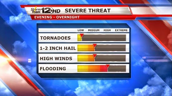
Friday evening/night: A widespread thunderstorm event is likely for most of Kansas. Some high wind is possible, but not likely to be as bad as Thursday morning turned out to be. Locally heavy rains can be expected too.
Saturday morning: Showers and storms likely in central and especially eastern Kansas, but should be winding down by late morning as they move out.
Saturday afternoon: Dry with some sunshine.
Saturday night:  Chances for storms in SW Kansas, but most areas will likely be dry
Severe weather risk over Oklahoma for Saturday afternoon and night
Sunday: Most of the day looking dry, but late day storms are expected to fire up in eastern Colorado and far western Kansas after 5 or 6 p.m.
Sunday night/Monday:  Another widespread shower/storm event likely in western Kansas for Sunday night and by early Monday, the rains should be back in central Kansas. The rain chance will linger all day in central and southern Kansas as a storm system slows over the state.

The biggest concern this weekend might be some localized flooding, especially in areas that have had heavy rains. We will have some other chances coming up next week, but we can discuss those on Monday.

Millie and I will have a good weekend. She's not running the Gladiator Dash (for obvious reasons) but I'll be out there Saturday morning (probably in the rain for a little while) It's another one of those obstacle course races that forces you to do things you wouldn't normally do as an adult (like crawling in the mud, wading through waist high water, crawling through giant underground culverts) but they sure are fun and adventurous.


Thursday, June 5, 2014

What a round & more to come

What a crazy morning this has turned out to be. It has basically played out the way we thought with storms firing up in eastern Colorado and moving across the rest of the state through the early morning hours. This is what meteorologists call a "mesoscale convective system" or "MCS" for short. But around 7 a.m. this morning, wind gusts of 80-90 mph were occurring in central Kansas near Ellsworth and Saline counties. Look at the radar image and I've drawn some arrows on here to indicate the counterclockwise circulation on the backside of the complex of storms. An MCS is a system of it's own that takes off and can last for many hours, feeding off of warm, moist air that we've had plenty of in Kansas the last several days. This batch of storms will keep going for awhile as it heads away from our area.
Tree damage in Ellsworth (courtesy Tina Bruning)


Tree damage in Ellsworth (courtesy Tina Bruning)
There was a multi-vortex tornado that passed near Limon, CO last night and 111 mph winds measured in Hugo, C) (which is southeast of Limon) and bad damage reported there too.

So when is the next round coming our way? I expect any of the storms Thursday night to be spotty at best, and the highest chances for rain will be along the Kansas/Oklahoma state line. They really need rain down in Oklahoma, and that's where some of the bigger storms will be heading into the evening and night. I think we can safely say, we won't have a wide swath of storms tonight like we did early this morning.

Future Track at 12 a.m. Friday
BUT.... we are forecasting another widespread event Friday evening into Friday night. Some of the storms will once again have a chance of producing high winds and some hail.

Rainfall reports coming in this morning through 8 a.m.:

Wichita: 0.88"
McPherson: 2.64"
Salina: 1.98"
Goodland: 0.96"
Hill City: 0.96"
Russell: 1.24"
Newton: 0.95"
Jabara Airport (NE Wichita): 1.21"
Hutch: 0.82"
Hays: 1.72"
Dodge City: 0.02"

Blog History