Tuesday, August 31, 2021

Another good rain looming - early fall just a week away

August is ending on a hot note as we once again see a building high pressure system across parts of the Plains states. We were lucky enough to avoid the heat dome at the beginning of the summer, but in the last month, it's been pretty stubborn. Even at this time of the year, when the high pressure moves overhead, you still run the risk of being near 100. 

Here's the summary of August in Kansas. Averaging out the highs and lows, you'll see that much of the state was near to above normal. It wasn't record setting, despite having anywhere from 6-10 days with triple digit heat.

Rainfall has been anything but widespread. Summer storms can be spotty, and that's about the only way you can sum up what has happened in the last 31 days. Even though drought has expanded, conditions could be worse. 


September averages look like this:

Next rounds of rain coming soon! We are anticipating a cold front into western Kansas Thursday evening and overnight. That brings a solid chance of rain back to western Kansas initially, and then it spreads east as we move into Friday. More clouds - rain - cold front = a return to 80s by Friday. 

The expectation is that Friday will have scattered rain/storms from morning into the afternoon. Latest models slow the front down, which should help to develop some nice rainfall amounts in a 24-36 hour period from Thursday night into early Saturday. Central and western Kansas may end up getting an inch of rain, while farther east the amounts will be slightly lower. But this could be our first widespread rain in quite some time. 

 
Early fall is showing up!

Just take a look at what happens right after Labor Day. Temperatures in the 70s and low 80s? Sure looks like we have a good chance of it. And with humidity going down too, I think you could call this the first taste of autumn. Who's ready?

Thursday, August 26, 2021

Hurricane watch & hopeful signs of rain/cooler weather

I mentioned the possibility of a hurricane developing in the Gulf of Mexico and making landfall soon. Confidence is reasonably high that landfall may end up being west of New Orleans sometime early next week (Monday, Aug 30th). The potential track is more easterly now, which really hurts the chances of this being a factor for Kansas.

Here's what the system looks like as of Thursday morning:

Models are similar in their idea that this will be a Louisiana storm, and it may intensify very quickly as it approaches the coastline. 

We will watch a cold front move across Kansas Sunday, which will intercept the tropical system and shove it farther east. This could be bad news for areas that are extremely wet already (like Tennessee), and bad news for Kansas because our worsening drought just keeps on expanding and intensifying. 

Weekend storms: We are still on the lookout for weekend rainfall, but it's not going to be the drought buster that some need. The cold front just isn't that strong and the overall setup is weak at best. Bottom line, it's not a good looking setup for widespread, soaking moisture. Set your expectations around .50", and if you actually get that much, you'll be doing good. Much of the state will get a lot less.

There are some other encouraging signs with September right around the corner. Rainfall will still be in very short supply next week (Aug. 30-Sep. 3), especially with the tropical system southeast of us. That will subtract some of our gulf humidity that may otherwise be moving northward. The map shown below (if it verifies) would indicate some rain potential in our first weekend of September.

However, in the week two outlook for September 4-10, there's reasonable hope for some rain (but not drought ending). 

Meteorologist Peyton Sanders did some research and came up with these stats. First fall cold front in the last 4 years shows it's reasonable to expect a dramatic change in the first 10-12 days of September. We know it's coming, but for now, it's probably going to be another week before things get turned around and we start seeing some much cooler air. 


I'll leave you with this - the 10-15 day outlook for temperatures FINALLY showing some signs of getting out of the heat wave. 


Tuesday, August 24, 2021

A hurricane for Kansans to watch - coming soon

The hurricane season peaks around September 10th and we are almost halfway through the list of names for the Atlantic basin. Next up is Ida and Julian, which should be coming very soon. It may not look like much, but the area of thunderstorms near Venezuela could very well develop into a tropical system soon. 

Right now, the National Hurricane Center is giving it a 60% chance of developing into a storm in 5 days, but there's a strong likelihood that given the warm water and the weak winds aloft that it will grow into a hurricane soon. It may not become a hurricane until the weekend, but conditions seem favorable for it to grow. Just look where the storm will be this weekend.

Leftover tropical systems rarely get to Kansas. In fact, the last one to do so was Hermine back in 2010. It came on shore as a tropical storm near Corpus Christi and then weakened as it moved up into southeast Kansas on September 10th. 

Our computer models will be all over the place for awhile, but there is some potential of the storm pushing farther north. At this time, it is a low chance for it to reach Kansas, but certainly possible. What we need is a strong high pressure over the southeastern US to help push the system into the central Plains. I'm not sure we will get that setup, but there's plenty of time for us to watch the setup and see what may be developing. And there are several more storms to watch out in the Atlantic. Each yellow "x" indicates a potential storm on the horizon. The tropics are very busy right now, but that may change in 3 weeks when the overall pattern changes again. 

Next Rain - Heat Relief:
It still looks like a cold front is coming to Kansas on Sunday. That will be our next hope of some rain and heat relief. Until then, anything that pops up over Kansas will be REALLY isolated.


Have a great day.

Wednesday, August 18, 2021

More smoke floating around + rain on temporary hold

Wildfires continue across the west and smoke has once again reentered our Kansas air. However, with this latest go around, most of it appears to be mid and upper levels. Two fires in particular, the Dixie and Caldor fires are contributing some of the most smoke. The Dixie fire is over 600,000 acres, but it sounds like some of it has been contained. 

Smoke in the mid and upper levels will give us the dramatic sunrise and sunset photos that we have been showing on the air all summer. However, air quality down near the ground won't be as bad thanks to a steady south wind bringing in air from better regions. The image below shows upper level smoke. White arrows show which way the wind is blowing FROM at roughly 18k feet.


More hazy skies are expected throughout Kansas come Thursday as the upper level winds come from the southwest. However, the plume may not be as thick for the end of the week, but it may still be noticeable in the early morning and late evening.


Late week storms:

I'm saddened to tell you that rain for the end of this week is not looking good at all. Models continue to show a cold front coming in, but almost all of the rain will travel north of Kansas. It's great news for Montana, Wyoming, and the Dakotas. Kansas is too far south to get the brunt of the moisture.

Thursday evening: Chances are mainly in the northwest. They will be scattered storms at best, but not very widespread in their coverage. Expect rain amounts less than .25" - these storms are not likely to stall for any length of time, so even where we do get storms, it doesn't look like very much rain.

Storms Friday? - not likely. Even though a front is coming through, chances remain slim. Midlevel temperatures may be too warm and much of the upper level energy will be too far north. A couple of late night storms are possible, but definitely not likely.


The final heat wave of summer? We know it is coming and as we coast into late August, I would expect this to be it. But models have struggled SO much lately finding the cool air. Sunday - Tuesday look HOT! We may see some 100s again, especially in western Kansas. All of the computers shift the big heat dome back to the west quickly, so it will cool down in the second half of next week. 


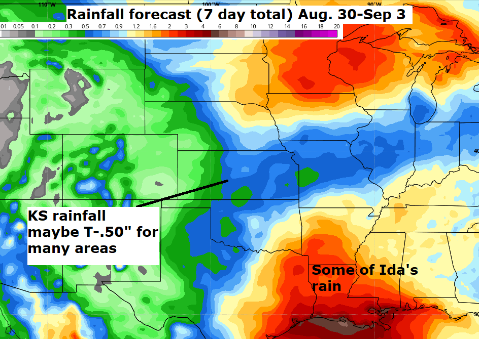
Rainfall forecast for the next 10 days: Great news for the northern Plains as drought easing moisture is coming. In Kansas, the best we can hope for now are some scattered storm chances mid-late next week with another cold front on the way. 


Friday, August 13, 2021

La Nina may continue to fall & winter + 30 day rain outlook

It's been awhile since I've posted anything related to El Nino or La Nina. And it's becoming apparent where we are heading as fall approaches and then questions start to swirl about what kind of winter we may have. 

Here's what the water temperatures are doing now:

As a refresher, La Nina refers to water temperatures along the equator in the Pacific that are colder than normal, while El Nino is the opposite. The average temperature has to be .5° Celsius either above or below for a period of at least 3 months in order to qualify. The table below shows the last 10 years of El Nino (shown in red) with La Nina (in blue)

It was about a year ago, we started slipping into a La Nina and it held on through winter and weakened a bit in spring. Now, as fall approaches it's looking more apparent that another La Nina is developing. Do you remember what happened last fall in a La Nina? Here's a reminder:

October was cooler than normal and we had an early season snow late in the month! Most of the month was DRY.
 
November flipped around and was quite warm - but we did get more moisture:

This fall could be very different. There is not a "one size fits all" approach when it comes to La Nina autumn for Kansas. However, consider this trend for a moment:
  • January - WARM
  • February - Record COLD
  • March - Warm
  • April - Warm
  • May - Cold
  • June - Normal
  • July - Below Normal
  • August - (so far) - Normal
More times than not, our average monthly temperature has been below normal. Keep that in mind as the fall months draw near. We can't say yet if we will have an early frost or not, but my gut feeling is that it will be right on time (or maybe a week or two early). Be sure to check back.

We are still optimistic about rain in the week ahead!
Some rain is forecast for Kansas Monday/Tuesday, and then the setup late in the week looks more premising for more areas of the state. 
 
There's a strong cold front that should be on the way, and if all goes right, it would be a widespread setup for moisture. I know the situation is still pretty rough around the state - we need the precip. I'll leave you with this map - the 30 day rainfall outlook for the Plains. It takes us to Sep. 13 and suggests that we may have a decent chance of getting above normal moisture during the period. Cross your fingers:


Thursday, August 12, 2021

Rain Rain - this could be a good sign

It's been the primary focus of recent updates here on the blog and for good reason. We need rain. There were some nice showers and storms last Saturday that covered a decent amount of Kansas, but near as I can tell from most of you, it wasn't quite enough. 

Here's what's going on for Thursday. If you look to the north, you can see a nice drop in temperatures as close as northern Nebraska by mid afternoon. This front will set off the majority of our storms heading into the evening hours. I don't think these storms will be able to survive the entire night, so after midnight, expect what's out there to dry up. Summer storms can be notorious for producing more wind than hail or rain, so keep that in mind in the coming days.

Friday:
Storms will once again be possible over many different areas. The front will still be in the area, so showers and storms will start late morning and continue into the afternoon. Much of what shows up on radar should continue to shift south throughout the day. There will be pockets of heavy rain, but threats of damaging winds and large hail look minimal.

This weekend:
Saturday:

Rain chance looks a bit better than the Sunday setup at this time. Least likely areas of the state to get rain will be in the far east. Central and western Kansas could deal with slow moving storms that gradually track south, and another .50" is a reasonable expectation. The clouds and rain should keep our highs in the 80s. Sunday (shown below) will still have some rain around too, but it's likely a morning chance and then drier weather takes over for the afternoon.
 

Potential amounts:
It's looking like most of the state will get something. Probably not enough to wipe out the growing drought conditions, but maybe enough to keep it in check. Much of the area will be close to an inch by the end of the weekend, but as is usually the case, some will get more and others less. 
 
There may be more active weather later next week!


A system tracking through Wyoming may help to set off a new round of rain and thunderstorms beginning Wednesday night (western Kansas) and then spreading east for Thursday. Timing could be adjusted as we get closer, but it may be more welcome moisture soon. AND... it will be followed by a BIG drop in temperatures as we go later in August. Just look at the period Aug. 19-26. How does 10-15 degrees below normal sound? Let's see how this sets up, but it is very likely with the pattern that we are heading into.


Friday, August 6, 2021

Rainfall forecast update

The waiting game continues and it is quite frustrating when we keep getting teased by these little showers that produce less than .25". Kansas (among many other areas) continue to be in the wrong spot for rain at this time and although chances are in the forecast, there's nothing out there that looks to break the ongoing dry spell. The chances are much better for cooler weather heading into mid-August, but rain continues to be elusive. 

Saturday:

Chances will begin late afternoon and continue into the evening/overnight. Given that we don't have a strong front coming through, there isn't much focus for storms to fire off of. Whatever develops will continue to move east-northeast, and rainfall totals will probably come in under .50" (and even less the farther west you go). A few storms may kick out some gusty winds - and help to cool down the late afternoon temperatures. 

Monday:

A cold front will try to push into northern Kansas during the evening. However, as it does so, it will be fading, so the heat isn't going to budge. There should be some storms developing north of I-70 near the weak front, and some of the rain will drift south before falling apart. I'm just not overly impressed with our potential of rain - so keep your expectations low. 

Wednesday:

This front may have the best chance of coming through Kansas. It's a setup that may increase the storm potential for a good part of the Plains, but there are some ingredients missing to give us hope of a soaking event. You'll continue to see us advertise a mid-week storm chance and that's what we are banking on, but if I had to forecast rain amounts for this particular timeframe, it wouldn't be much more than some .50" totals. 

Here's a summary of the rainfall forecast (through Sunday, August 15): Nice to see something on it, but we will need a bunch more. 


Have a great day. Cooler weather should be back in the Plains very soon. I'm looking at Aug. 15/16 for some really comfortable weather to push back this way. 

Tuesday, August 3, 2021

Very dry in Kansas, but hopeful signs are showing

Here's a quick snapshot of rainfall numbers compared to normal since June 1st (beginning of meteorological summer). Point being is that we have some dry and REALLY dry areas in Kansas right now - fall crops are suffering after last weeks heat. And there's more hot weather to get through down the stretch, especially as we head into the weekend. 


Here's a map that backs up some of the numbers shown above. 

The extreme dry weather covers not just Kansas, but most areas north of us too. Look at Minnesota and northern Iowa. We know summer storms can be so isolated, and this map backs that up 100%. If you've had a few inches of rain in the last couple of weeks, you are in the minority for sure.

This weeks pattern isn't really all that exciting for moisture:

The upper high retreated westward over the weekend and we get benefiting from some much more comfortable weather. However, we are waiting on the upper level high to reemerge out in New Mexico by the weekend, which will heat things up for the Plains. Highs return to upper 90s and near 100 very soon. Humidity will slowly creep up in the coming days, but shouldn't be unbearable anytime soon.

Second week of August looks more promising for rain:

Our computer models rarely agree (which is a topic for another time), but we do see some agreement among them suggesting next week will have a few more rain chances mixed in for the Plains. Just take a look at the period August 9-15:

I don't think it will be blockbuster rainfall totals, but even if we could get some 1/2 to 1 inch amounts, it would be a nice band aid for now. 

And although next week looks pretty warm from the Plains to the east coast, if you look at that pocket of cooler air up in Montana and North Dakota, that should be coming our way in mid-August. 

Don't forget:

The Perseid meteor shower is ramping up. It will peak next week, but you can start your viewing now if you like. I'll post more about this later, but if you are getting out the next several nights, keep your eye out for one of the best meteor showers of the year. 

Blog History