Tuesday, September 27, 2022

What's coming up for Kansas? Hmmmmmmm

Coasting toward a new month - and if you had to take a wild guess at what it will be like for Kansas, you would most likely be right. Let's see, every other month has been below average rain and above average temperatures, and that's the early indicators for this upcoming October (there's more down below). 

Here's a quick summary of rainfall for the last 14 days (which pretty much takes into account what we had all month) - even though there was some rain just prior to this period. 

And now some numbers since July 1st (for the major reporting stations across the state) - given how spotty rains have been, this may not be good representation for your area. 

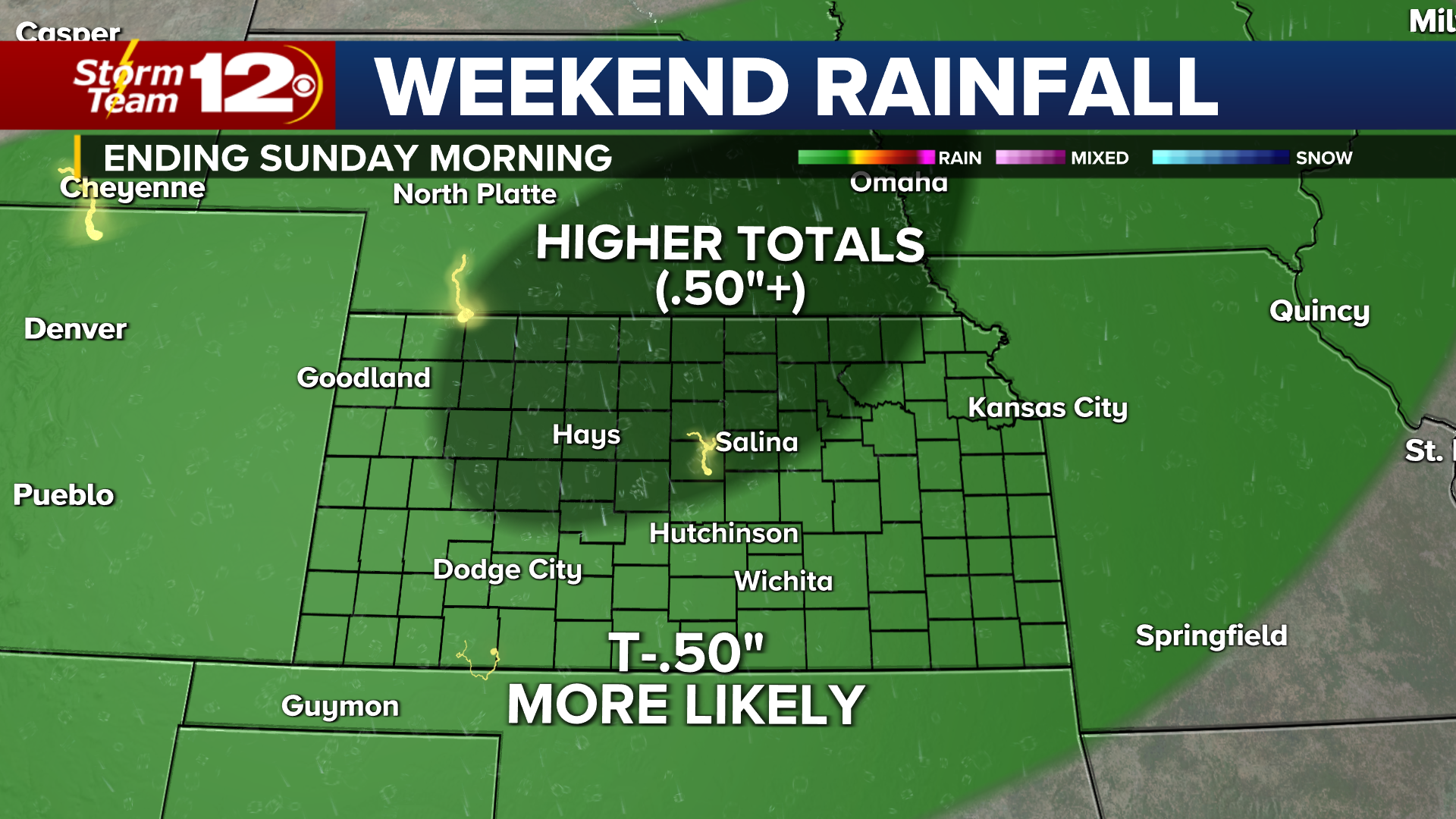
Into early October - we expect to get squeezed between leftovers from the tropical system "Ian" to the southeast and another weak system coming into the Rockies around the 1st of the month. As you would expect, Ian is too far east to do us any good in the Plains. The western system approaching is to weak for anything more than some hit/miss showers. 

What does October look like as a whole?

In a nutshell, it's basically more of the same. Rainfall that might be enough to get some newly planted wheat to sprout - green up some grass, but not enough to make a huge dent in drought conditions. Two time periods where rain chances might ramp up a bit. One will be in the Oct. 10-15, with a second stretch of some active weather about 8-10 days prior to Halloween (very preliminary thoughts, but some of what we are seeing down the road). Models can really struggle this time of year during the seasonal transitional to winter, but it's what we have to analyze at this point. 

Here's the first potential active stretch in October:

Followed by this later in the month:

La Nina is still in the driver seat for now. We are seeing a slow weakening of the phenomenon and that should continue down the road, but we know its influence will still be there as winter arrives.


Wednesday, September 21, 2022

Two rounds of rain - but are we still in the same ol' pattern

Week after week we continue to talk about the need for rain and how desperate some areas are right now. Well, two rounds of rain are coming and at least for a few, this might be the biggest rain in many, many weeks. 

Round #1 will arrive Wednesday-Thursday morning:


The rain will begin across Nebraska, Colorado, and extreme northern Kansas. As time wears on and we get into Wednesday night, we will see that area develop and shift to the south. Unlike some of our recent rounds of rain, this stuff might stick around for awhile, and provide some welcome amounts. 


Round #2: Expected Thursday night/early Friday: This batch of moisture will be lighter than the first round. I would expect amounts to be less than .25" 


Adding it all up yields a map that looks like this:


Rain amounts since July 1st:

Any break in the pattern soon?

Short answer is no. There just isn't anything suggesting we are moving out of this ridiculously dry pattern soon. I think we are remaining hopeful it's nearly over, but fact of the matter is moving into early October, it continues to look warmer than average and still no clear signals of continuing rain potential.


Look out Gulf of Mexico - next week:
Hurricane season has taken off and after watching a few storms in the Atlantic with no threat to the US, attention will be on the Gulf of Mexico next week. What could become "Hermine" may impact the southeast, including Florida. Plenty of time to watch, but this system is forming now near the Windward Islands. I don't think there is any chance of the system getting far enough west to have some impact on Kansas weather. It's rare that Gulf storms make it up to the central US, but it has happened before.


Tuesday, September 13, 2022

The beat goes on - but maybe next week?

We did get some rain last weekend, but as expected, it wasn't near enough for anybody to really jump for joy. I did glance at the USDA Kansas Crop and Production Process on Monday - it's no surprise. Nearly 50% of soybeans were poor or very poor and 53% of sorghum was poor or very poor. 

Here are some more rainfall records and stats for Wichita, Goodland, and Dodge City. 

Wichita: In order to find a period with LESS rainfall than the one we are currently in, you'd have to go back to 1988!


Goodland: Last year wasn't very good for rain - one of the drier June to September periods on record. Terrible drought happened in 2012 and only produced 4.19" in the 4 month time span.

Dodge City:

It definitely feels like we are beating a dead horse here. Week after week, no rain and warmer than average temperatures. 

What we're watching for next week:

There's a chance another breakdown in the heat will arrive with a system tracking out of the northwest and the Rockies. It's early yet, but the timing of our next cold front is a week away. It's a little crazy to think about - we are in mid-September and the next chance a cold front arrives is 7 days away. This setup COULD be helpful - if the front and entire system doesn't fall apart between now and then. In order to make a dent in drought, we will need a very slow-moving front, or an upper-level system that sits in the southwest and just cranks out multiples waves of rain. One of those scenarios MIGHT play out next week. Again, it is a week away, but we are desperate for rain and trying to find something out there.

In the image above, you're looking at a map of winds (about 18,000 feet off the ground - those are the white arrows-the colors blue and green represent how fast the wind is blowing) The front is happening near the ground. If the front slows down Tuesday-Thursday (as advertised by some models) and the upper-level winds go parallel (the setup shown above), this might be a helpful scenario. However, big rains lately have passed us to the south and that's something to be concerned about. See for yourself - if nothing changes in the data, heaviest rains will be focused central & east. There's still a chance the front may setup farther west, or it could end up all going south and east of us too. 


Just sharing the information as we see it - hoping something will turn up in our favor soon. I know this is as frustrating as it gets, but there isn't anything we can do except sit and wait for our turn to come.

Wednesday, September 7, 2022

First taste of fall & SOME rain - still not near enough yet

The Kansas State Fair is about to start, and I'm told time and time again "it always rains during the fair" - so our predictions of rain this weekend should hold up. At least, it's making me feel more confident. It also feels like one weekend is chilly and the other one you fry. Where is the state fair historian - I know some of you can recall some pretty weird weather during the 10 day event. 

At any rate, we are gearing up for our next chance for rain. It's a cold front (and we haven't seen many of those lately) and it should be coming through Saturday. This will be one of those days where it's chilly in northwest Kansas and cooking in the south. Might be a 40 spread from west to east Saturday. Get ready.

10am temperatures:

7pm temperatures:

We should get some rain - since it's the fair and all - but I don't want you to get your hopes up for huge amounts. Here's why:

Upper-level winds on the Gulf coast are moving in the wrong direction (blowing northeast to southwest) and that will carry the rich humidity away from the Plains. The wind goes counterclockwise around a low pressure system. You can still get rain without a Gulf connection, but the amounts are not likely to be anything spectacular for most areas, and the heaviest stuff is usually much more isolated.

We still expect to see most of the rain Saturday/Saturday night - starting north and spreading south as the very cool air continues to push in. Much of the rain will come BEHIND the front, so you'll probably notice a wind shift first, temperatures going down, and then the rain chances start to increase.

12pm - most rain west and north:


8pm - rain does spread farther south and east, but it will likely be a slow process


Sunday - 6am - rain begins its exit to the east

Again, it doesn't appear the amounts we will get anything heavy, but amounts might be highest over northern Kansas and slightly less farther south.

It's such a tall order finding rain these days, but we keep looking out there for something. Couple of things - the heat DOES come back next week, but the high pressure is not going to be very strong. That should keep us from seeing any record heat. Also, there may be some small chances for rain mixed in toward the end of the week. Looking at the period from Thursday (Sep. 15-18), but I'm not too excited about it being heavy.

Have a great day.

Friday, September 2, 2022

A potential tropical connection to KS - September outlook

Anybody else ready for different weather? I can honestly say, not since 2011 or 2012 have I felt like we are saying the same thing on the air every evening "tomorrow is hot with no rain". Or lately, it's been "tomorrow is hot, and a stray storm might pop up". It's been pretty monotonous lately. I mean, just look at the last half of August, and the afternoon highs range from 91-98. This is Kansas and not Florida or California, right? 

August Rain (or lack thereof)
Here's a map showing the "rainfall departure from average" - over the last 30 days. It's not good, but you already knew that. The key is off to the right - yellow and orange would be 2-3 inches below normal.

Latest drought map:
And that's why we start September with a map that looks like this:

September rainfall isn't much (on average) - but even if we were to get "normal" rainfall, it won't solve all of our problems with drought. It's a long process and so much water is needed to catch us up. Most of Kansas averages 1.50-3 inches over the month.

First up in September:
Our first interesting setup of the month could involve some tropical moisture as we head toward the start of the Kansas State Fair. What I think will become tropical storm or hurricane "Kay" should move north and crash into Mexico on or around Wednesday, Sep. 7th. See the map below:


If that happens, the mountains in Mexico will tear the storm apart fast. However, the leftover moisture may continue to move north and head toward the southern US at the end of the week. At the same time, a potent system coming from the west will be interacting with the leftover moisture. Is this a setup to get some good rains? It's early and might seem like a long shot - but something to watch. I would expect increasing rain potential next weekend (Sep. 10/11)


September outlook:

Temperatures won't likely be anything out of the ordinary. It sure looks like any cool weather will be balanced by the warm days, so near normal is the safest expectation here. 

Rainfall: 

I do expect this month of September to have more rain than August, but that's not saying much considering much of the state didn't have much at all. Early indications are the next 28-30 days will have near normal rain, which when all is said and done, is not much more than a few inches at best. 

Have a good day. Thanks for spending a few minutes here.

Blog History