
We don't expect any radical shifts in the weather for the remainder of the week. Even into the upcoming weekend, it's unlikely to change dramatically.

The bitter cold temperatures (Arctic air) is lodged up in central Canada and not likely to move south for a little while yet. We look at the "AO", which stands for Arctic Oscillation. When its positive, you are more likely to be mild. When it goes negative, watch out. The area circled indicates where we've been lately. But notice it dipping down around January 1st. It's going to turn cold (and perhaps very cold) right around the first of the year.

This weekend:


One feature to keep an eye on will be coming over the Rockies Saturday night/early Sunday. There's a chance this system will bring some light snow or flurries to eastern Colorado and parts of western Kansas. It's doubtful that we will get much from this system, given that it's coming right over the Rockies and likely starved of moisture.
Healthy storm next week:
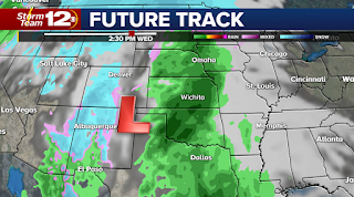

Just beyond Christmas, we could see a big storm developing in the Plains. Confidence on precipitation TYPE and AMOUNTS is low at this stage, but the computer models have been hinting at something developing. The lack of cold air lately is suggesting this might be more of a rain producing system rather than a ton of snow, but it's really hard to say when you are still a week away. But anyone planning to be on the roads just after Christmas should take note of this potential storm.
We will provide updates online and of course, right here on the blog. Have a great day.
No comments:
Post a Comment