
I mentioned the possibility of a hurricane developing in the Gulf of Mexico and making landfall soon. Confidence is reasonably high that landfall may end up being west of New Orleans sometime early next week (Monday, Aug 30th). The potential track is more easterly now, which really hurts the chances of this being a factor for Kansas.
Here's what the system looks like as of Thursday morning:

Models are similar in their idea that this will be a Louisiana storm, and it may intensify very quickly as it approaches the coastline.

We will watch a cold front move across Kansas Sunday, which will intercept the tropical system and shove it farther east. This could be bad news for areas that are extremely wet already (like Tennessee), and bad news for Kansas because our worsening drought just keeps on expanding and intensifying.

Weekend storms: We are still on the lookout for weekend rainfall, but it's not going to be the drought buster that some need. The cold front just isn't that strong and the overall setup is weak at best. Bottom line, it's not a good looking setup for widespread, soaking moisture. Set your expectations around .50", and if you actually get that much, you'll be doing good. Much of the state will get a lot less.

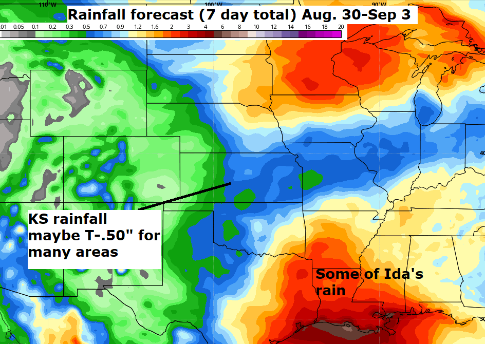
There are some other encouraging signs with September right around the corner. Rainfall will still be in very short supply next week (Aug. 30-Sep. 3), especially with the tropical system southeast of us. That will subtract some of our gulf humidity that may otherwise be moving northward. The map shown below (if it verifies) would indicate some rain potential in our first weekend of September.
However, in the week two outlook for September 4-10, there's reasonable hope for some rain (but not drought ending).

Meteorologist Peyton Sanders did some research and came up with these stats. First fall cold front in the last 4 years shows it's reasonable to expect a dramatic change in the first 10-12 days of September. We know it's coming, but for now, it's probably going to be another week before things get turned around and we start seeing some much cooler air.

I'll leave you with this - the 10-15 day outlook for temperatures FINALLY showing some signs of getting out of the heat wave.

No comments:
Post a Comment