Our mini-May heat wave continues for another day with some record highs that will be tied or broken by the end of the afternoon. Yesterday we had two (Russell and Smith Center) and keep in mind our high should be in the upper 70s. But then again, how often does Kansas have weather that follows the "norm". It's rare.
 |
| Storm chances for Wednesday evening |
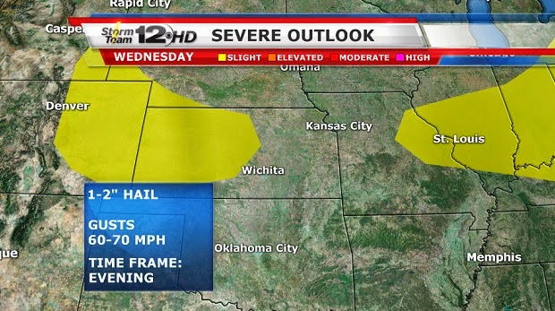 |
| Severe threat Wednesday |
 |
| Chances for storms cover more of the state on Thursday |
It looks to stay dry today, but things begin to get active tomorrow evening in western Kansas and then chances ramp up for the rest of the week and through the Memorial Day weekend. Trying to figure out the timing is the most difficult part right now. I think we can safely say that Wednesday evening/night, chances will be in the west and north of I-70, and then almost all of the state will have a chance come Thursday evening. The chances will again be statewide Friday as a front just meanders over the area. I know this doesn't sound encouraging for the holiday weekend, but if this is what it takes to make it rain, I declare the next 3 weekends to be holidays. (wouldn't that be nice - 3 day weekends for the next 3 weeks) The forecast rainfall amounts from our Future Track are pretty small, but it also cuts off Thursday evening (before most of us have a chance to see the moisture). Heaviest amounts are to the north, but I think we have a good chance to see some 1-2 inch amounts around the area before the holiday weekend comes to an end.

Some severe storms are possible each day, but a widespread, severe weather event is not expected anytime soon.
Millie is very intrigued with something on the IPad. Can you figure out what she is looking at? It's not a milk bone.
(Answer: a web camera in Rockies - near Breckenridge) Probably not as exciting as you had hoped.


1 comment:
Just so happy for a rain chance thanks to you and millie
Post a Comment